AI Powered Forest Intelligence
Visualization: Autonomous drones, LiDAR scanning, artificial intelligence, and digital forest twins converge into a new generation of intelligent ecosystems | Image: © Ulrich Buckenlei | VISORIC GmbH
Forests are among the most complex ecosystems on our planet. They store carbon, regulate water cycles, protect biodiversity, and provide essential resources for industry and society. At the same time, they are increasingly under pressure from climate change, prolonged droughts, pest infestations, and extreme weather events. To better understand these changes, new technologies are emerging that can capture and analyze forests with unprecedented precision.[1]
Modern drones, LiDAR systems, and AI powered analytics platforms are transforming the way forestry is conducted. What once relied on sampling methods, field inspections, and periodic inventories is increasingly evolving into continuous digital observation of entire forest landscapes. Millions of data points capture individual trees, canopy structures, biomass, growth patterns, and environmental changes almost in real time.[2]
The cover image of this article illustrates exactly this transformation. Above a natural forest, an intelligent digital twin emerges that not only represents the physical structure of the ecosystem but simultaneously integrates information about tree health, carbon storage, biodiversity, and environmental conditions. As a result, the forest evolves from a natural landscape into a data driven information system that can be continuously monitored, analyzed, and understood.
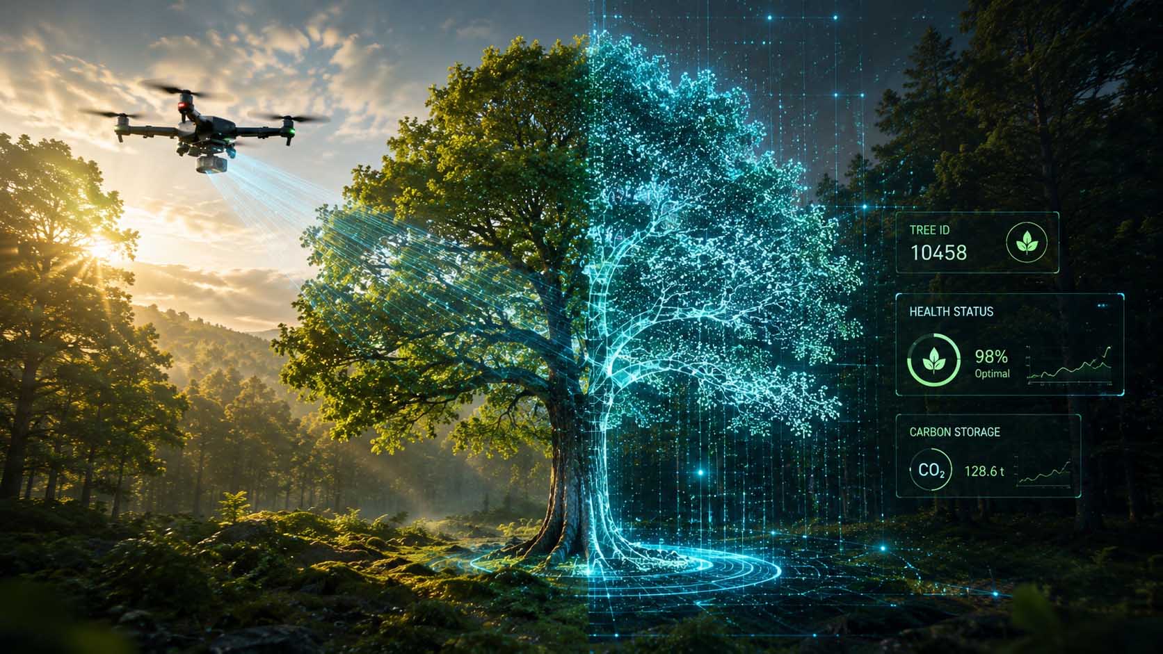
AI Powered Forest Intelligence
Visualization: A digital forest twin combines drone acquisition, LiDAR point clouds, artificial intelligence, and real time data into a new form of ecological intelligence | Image: © Ulrich Buckenlei | VISORIC GmbH
This development becomes particularly exciting at the intersection of remote sensing, artificial intelligence, digital twins, and real time 3D technologies. Forests are no longer merely mapped but modeled as dynamic systems whose condition can be continuously monitored and analyzed. This creates new opportunities for forest conservation, climate research, resource management, and long term sustainability strategies.[3]
Major research programs, space agencies, and technology companies are also increasingly investing in digital forest models. From autonomous drone fleets and AI powered health analysis to planet scale digital twin platforms, a new generation of intelligent environmental technologies is currently emerging. The goal is to better understand ecological processes and support informed decision making based on current data.
The key question is therefore no longer simply how we capture forests. Increasingly, the focus is shifting toward how artificial intelligence can help us understand, predict, and protect entire ecosystems over the long term.
- Drones capture forests in high resolution and in an automated manner
- LiDAR creates digital twins of individual trees and entire forest landscapes
- AI detects diseases, risks, and environmental changes at an early stage
- Real time data improves climate research and resource management
- Digital forest twins create new foundations for sustainable decision making
This development becomes especially fascinating where drone data, artificial intelligence, and digital twins combine to create a continuously updated digital representation of our natural environment for the very first time.
Drone Based Data Acquisition in Forests
For a long time, forest monitoring relied on sampling methods, manual surveys, and periodic field inspections. Foresters documented tree species, trunk diameters, and stand sizes directly on site. Although these methods provided valuable information for decades, they were time consuming, costly, and often applicable only to limited areas. At the same time, much of the forest’s development remained invisible between inventory cycles.[4]
This is precisely where modern drone systems are changing the rules. Equipped with high resolution cameras, LiDAR sensors, and other remote sensing technologies, they can survey large forest areas within a short period of time. Millions of measurement points document tree heights, canopy structures, terrain features, and vegetation patterns with a level of accuracy that only a few years ago would have required significantly greater effort.[5]
Humans typically view forests from the perspective of individual locations. Drones, by contrast, provide a complete overview of entire landscapes. From above, a highly detailed digital representation of the forest is created that can be continuously expanded, updated, and analyzed.
Autonomous Data Acquisition from the Air
Visualization: Autonomous drones survey forest areas using LiDAR, high resolution sensors, and intelligent data acquisition systems for the next generation of digital forest models | Image: © Ulrich Buckenlei | VISORIC GmbH
This development becomes particularly powerful through the combination of multiple sensing technologies. In addition to conventional imagery, modern systems capture elevation information, vegetation structures, and georeferenced environmental data. As a result, they generate not only a digital map of the forest but also a comprehensive data foundation for future analyses, simulations, and digital twins.[6]
Major research programs and environmental organizations are increasingly adopting drone based data acquisition. The technology enables more frequent updates, improved comparability of measurements, and significantly more precise documentation of ecological changes over extended periods.
- Drones efficiently and automatically survey large forest areas
- LiDAR generates millions of highly accurate measurement points
- High resolution terrain and vegetation models are created
- Large scale forest inventories become faster and more accurate
- The data foundation for digital twins is established during flight operations
However, data acquisition is only the first step. The most exciting developments begin when billions of measurement points are transformed into complete digital representations of individual trees and entire forest landscapes.
Hier ist die Übersetzung im unveränderten HTML Format:
Building the Digital Forest Twin
Once drones, LiDAR systems, and sensor platforms have captured their data, the actual transformation process begins. Millions of individual measurement points are converted into digital representations of trees, forest areas, and entire landscapes. The collected information is not merely stored but integrated into structured spatial models.[7]
For a long time, creating realistic 3D models required extensive surveying, manual modeling work, or complex geospatial data processing. Modern digital twin platforms now go significantly further. Point clouds, imagery, and terrain models are processed automatically and combined into highly accurate digital representations of real forests. Each tree is assigned a unique spatial position within the virtual ecosystem.[8]
This creates far more than a three dimensional visualization. The digital forest twin represents real world structures, topographies, and vegetation patterns while establishing the foundation for future simulations, analyses, and AI powered decision making processes.
From Captured Data to Digital Ecosystems
Visualization: LiDAR point clouds and drone data are transformed into digital twins of individual trees and complete forest landscapes in real time | Image: © Ulrich Buckenlei | VISORIC GmbH
The image in this chapter illustrates exactly this transition. Real forest structures are gradually transformed into digital models. Individual measurement points become spatial objects, objects evolve into digital forest landscapes, and these landscapes ultimately become complete digital twins with high spatial accuracy.
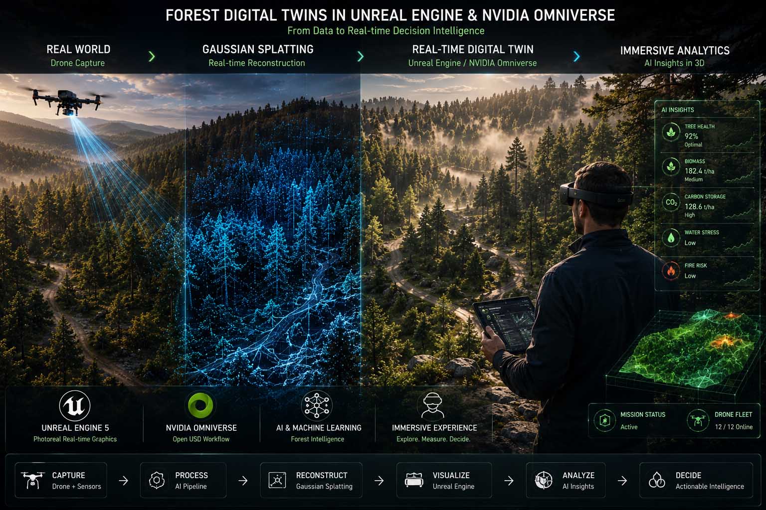
Modern platforms such as NVIDIA Omniverse, Unreal Engine, and geospatial digital twin systems create entirely new possibilities for the visualization and utilization of such models. Forests are no longer simply documented but transformed into interactive digital environments that can be analyzed, simulated, and continuously updated.[9]
- Point clouds become complete digital forest models
- Each tree receives a precise spatial position
- Digital twins replicate real forest structures
- Interactive 3D environments replace static maps
- The foundation for AI analysis and simulation is established
Yet even highly accurate digital twins are only the beginning. The most exciting developments emerge when artificial intelligence starts making information visible that remains hidden from the human eye.
Seeing Beyond the Human Eye
Once digital forest twins have been created, the true strength of modern Forest Intelligence systems begins to unfold. The collected data is not used solely to visualize trees or landscapes. Artificial intelligence analyzes the information and identifies patterns that are often invisible to the human eye. This is where the distinction between a digital map and an intelligent ecosystem model becomes apparent.[10]
Modern drones capture far more than traditional RGB imagery. They combine high resolution cameras with LiDAR sensors, multispectral imaging, and additional remote sensing technologies. This creates multiple perspectives of the same landscape. While humans primarily perceive colors and shapes, artificial intelligence identifies additional information about vegetation health, biomass, water stress, and changes within forest canopies.[11]
Particularly powerful is the combination of different data types. Point clouds provide highly accurate elevation information, multispectral sensors capture vegetation characteristics, and AI models combine these datasets into a comprehensive picture of forest conditions. This creates a form of digital perception that extends far beyond traditional observation.
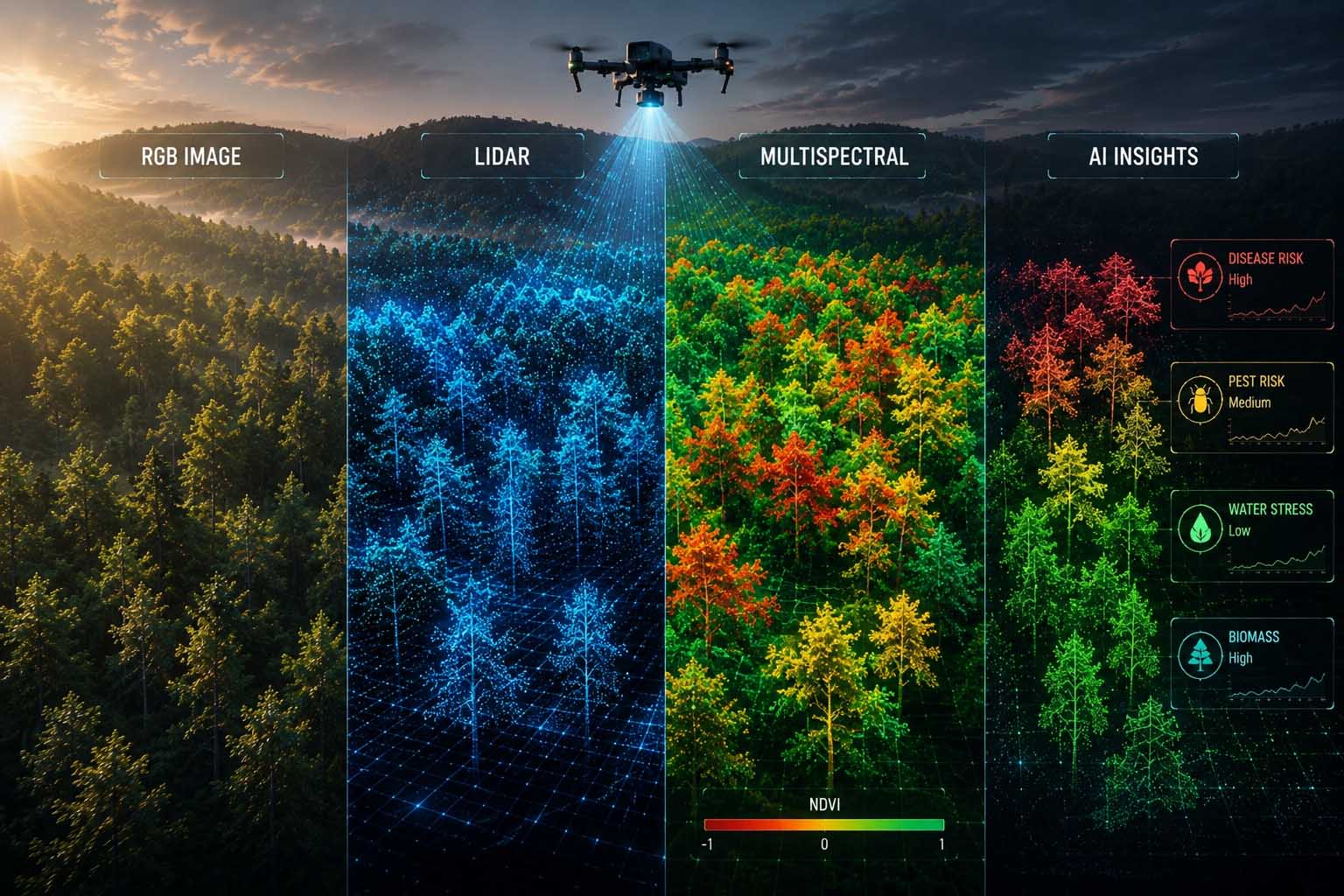
From Observation to Prediction
Visualization: Combination of RGB imagery, LiDAR point clouds, multispectral data, and AI analysis to detect hidden patterns within forest ecosystems | Image: © Ulrich Buckenlei | VISORIC GmbH
The image in this chapter presents multiple analytical layers of the same forest landscape. Visible structures are enriched with additional data layers that reveal biomass, vegetation conditions, and potential environmental changes. AI interprets the forest not merely as a landscape but as a complex system composed of millions of interconnected data points.
This creates entirely new opportunities for research, environmental monitoring, and modern forestry. Changes can be detected earlier, future developments can be predicted more accurately, and interventions can be planned more effectively. The combination of advanced sensing technologies and artificial intelligence therefore establishes a new form of data driven environmental analysis.[12]
- LiDAR complements traditional imagery with precise elevation information
- Multispectral sensors reveal hidden vegetation patterns
- AI identifies relationships often overlooked by humans
- Multiple data sources are integrated into a unified analysis platform
- Forests become interpretable as data driven systems
Even the most advanced analyses only create value when they generate actionable insights. The most exciting developments emerge when artificial intelligence begins predicting forest health conditions, environmental risks, and future ecosystem changes.
AI Powered Tree Analysis
As soon as artificial intelligence gains access to digital forest twins, LiDAR data, and multispectral analyses, a new form of ecological intelligence emerges. Systems no longer merely identify trees or landscapes but analyze their condition, development, and potential risks. This is the point where data acquisition evolves into an active decision support tool.[13]
Modern AI models can detect changes within tree canopies, assess health conditions, and identify anomalies long before they become visible to humans. Drought stress, pest infestations, or early signs of disease often leave patterns within the data that intelligent systems can recognize at an early stage. This creates new opportunities for preventive forest management and sustainable resource protection.[14]
Particularly interesting is the scalability of these systems. While individual experts can only analyze limited areas, artificial intelligence can evaluate millions of trees simultaneously. Each tree becomes a digital dataset containing individual characteristics, historical developments, and current condition information.
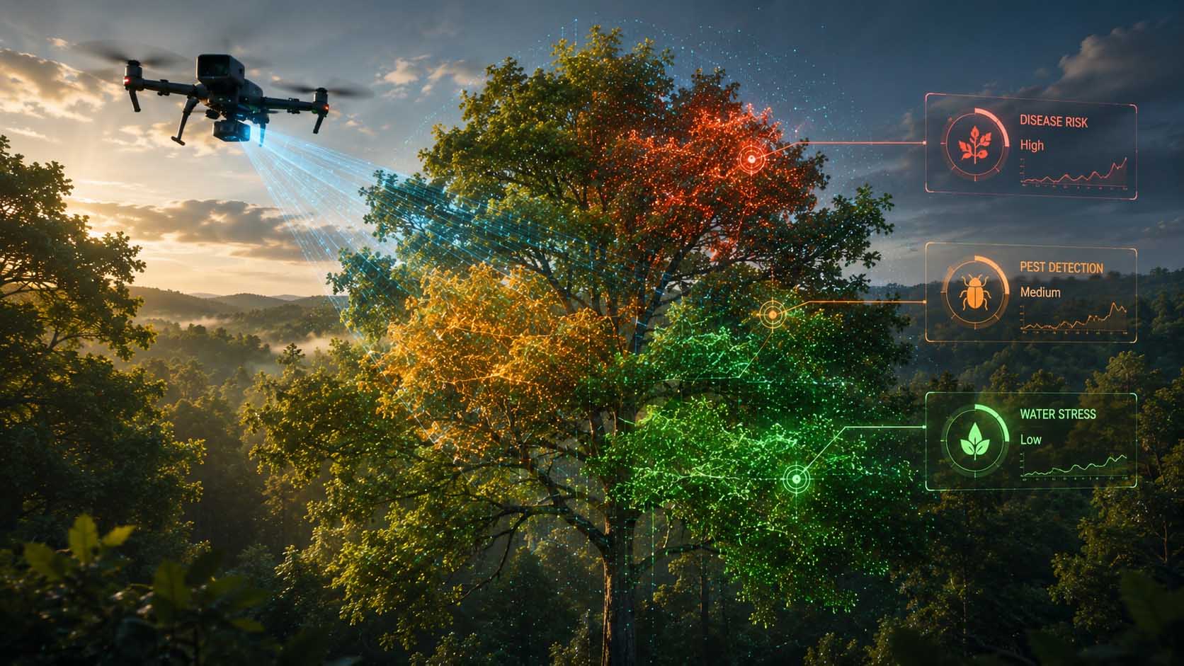
From Observation to Prediction
Visualization: AI analyzes tree health, pest infestations, water stress, and ecological changes based on digital forest twins and multisensor data | Image: © Ulrich Buckenlei | VISORIC GmbH
The image in this chapter illustrates how artificial intelligence makes different tree conditions visible. Areas with elevated risk, vegetation changes, or potential stress factors are automatically highlighted, enabling much faster assessment of large forest regions.
This creates significant value for modern forestry, nature conservation, and climate research. Decisions are no longer based solely on field observations but on continuously updated analyses of large scale datasets. The combination of digital twins and artificial intelligence opens entirely new possibilities for sustainable environmental strategies.[15]
- AI detects diseases and pest infestations at an early stage
- Drought stress and environmental changes become visible
- Millions of trees can be analyzed automatically
- Digital twins provide the foundation for predictive models
- Forest management becomes data driven and proactive
This development becomes especially exciting when individual analyses are combined into large scale environmental intelligence systems that enable continuous monitoring of entire regions.
Carbon Analysis and Climate Monitoring
Analyzing individual trees already provides valuable insights. Forest Intelligence becomes even more powerful when entire forest landscapes are viewed as interconnected systems. Forests store enormous amounts of carbon, influence regional climate models, regulate water cycles, and form the foundation of numerous ecosystems. To better understand these processes, new digital tools for large scale environmental monitoring are currently emerging.[16]
Modern drones, satellite systems, and digital twins make it possible for the first time to continuously capture ecological changes. Instead of analyzing isolated measurement points, entire forest regions can be assessed regarding biomass, carbon storage, vegetation development, and potential climate risks. This creates a much broader understanding of the interactions within natural systems.
Particularly exciting is the combination of real time data and artificial intelligence. Environmental information is not only collected but automatically interpreted and evaluated. High risk regions can be identified at an early stage. Changes become visible before they are apparent to humans. As a result, a new form of digital climate intelligence emerges from environmental data.[17]
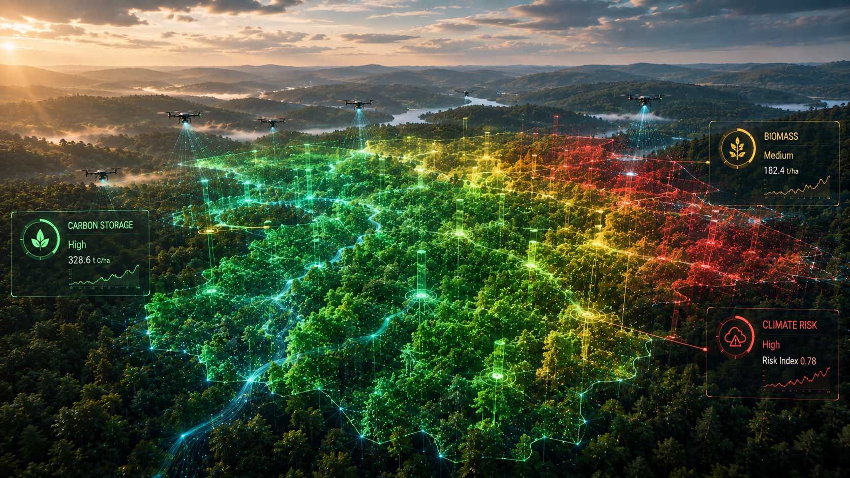
Forests as Living Climate Data Sources
Visualization: Digital forest twins combine carbon storage, biomass analysis, climate risks, and environmental monitoring into an intelligent decision making platform | Image: © Ulrich Buckenlei | VISORIC GmbH
The image in this chapter presents a forest landscape that is no longer viewed solely as a natural environment. Additional data layers reveal which areas store significant amounts of carbon, which regions are exposed to climate related stress, and where changes are occurring within the ecosystem.
This creates new opportunities for research, conservation, and sustainable resource management. Decisions can be based on data, developments can be monitored over the long term, and environmental measures can be planned more accurately. Forest Intelligence is therefore becoming an important tool for connecting digitalization and sustainability.[18]
- Digital twins make carbon storage visible
- Biomass and vegetation development can be continuously monitored
- AI supports climate risk assessment
- Environmental monitoring becomes large scale and data driven
- Sustainable decisions are based on current real time information
However, even comprehensive environmental intelligence reaches its full value only when it is continuously updated and available in real time.
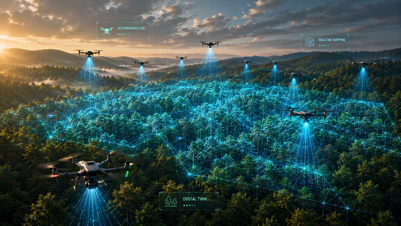
Real Time Forest Monitoring
Traditional forest inventories provide snapshots in time. Months or even years may pass between surveys. Modern Forest Intelligence systems follow a different approach. Digital forest twins are continuously updated and evolve into dynamic information systems that make changes visible almost in real time.[19]
Autonomous drone fleets, sensor platforms, and AI analytics work closely together. New data is automatically captured, processed, and integrated into existing models. As a result, the digital twin not only represents the current state of the forest but also documents its development over extended periods.
This becomes particularly valuable for large forest regions. Changes within specific areas can be detected automatically. Anomalies become visible before they reach critical levels. A static model evolves into a continuously updated decision platform for forestry, research, and environmental management.[20]
From Periodic Surveys to Continuous Forest Intelligence
Visualization: Autonomous data acquisition, real time analytics, and digital forest twins merge into a continuously updated environmental platform | Image: © Ulrich Buckenlei | VISORIC GmbH
The image in this chapter illustrates how digital forest twins are continuously expanded through ongoing data acquisition. New information flows directly into the models, creating an up to date representation of the real environment. This results in a living dataset that extends far beyond traditional mapping.
This offers significant advantages for public authorities, environmental organizations, and industry partners. Developments can be detected earlier, risks can be assessed more accurately, and resources can be allocated more efficiently. At the same time, a new level of transparency emerges regarding the dynamics of natural systems and their long term changes.[21]
- Digital twins are continuously updated
- Autonomous drone systems provide current environmental data
- Changes become visible at an early stage
- Real time information improves decision making
- Forests evolve into intelligent data systems
This development becomes especially exciting where captured data is not only analyzed but transformed into photorealistic digital worlds that can be explored and simulated interactively.
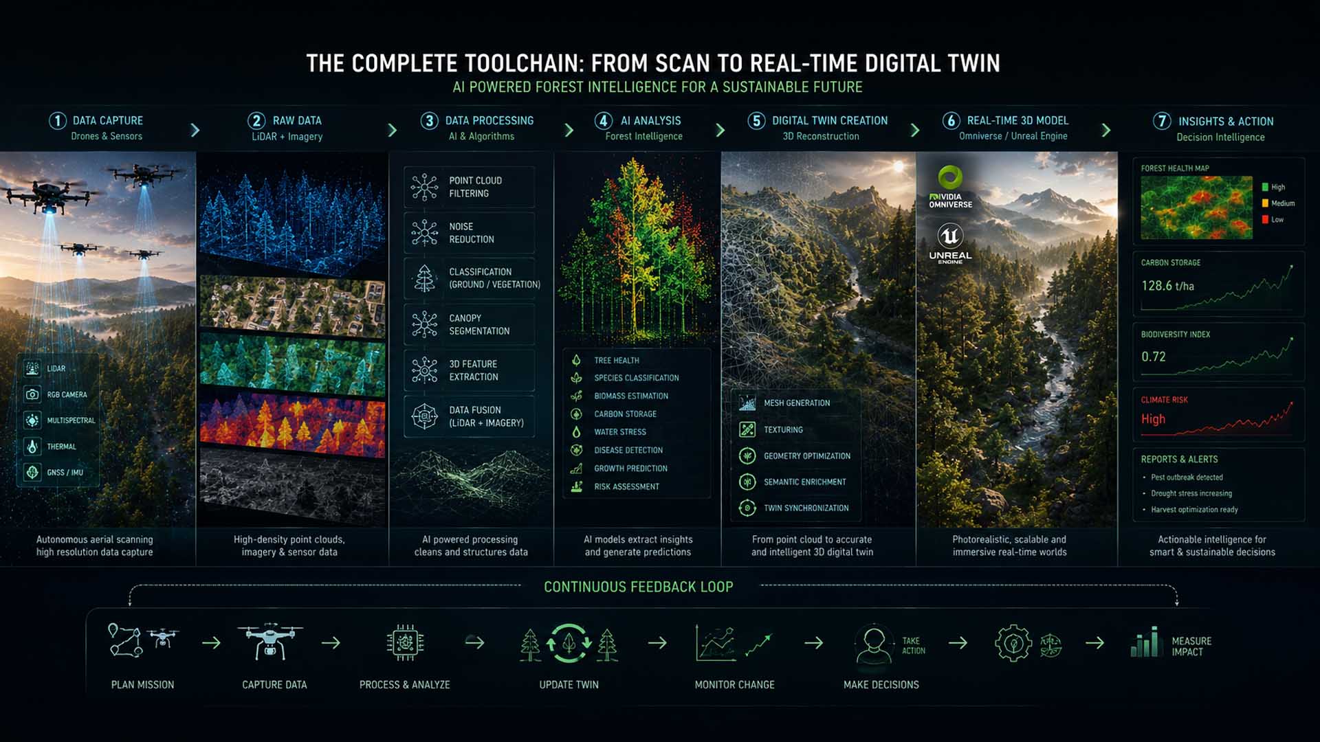
From Point Clouds to Living Digital Twins
Capturing and analyzing forest data is only the foundation of modern Forest Intelligence systems. The real value emerges when billions of measurement points are transformed into understandable, usable, and interactive models. This is where digital twins, real time rendering, and advanced reconstruction technologies come into play. They transform abstract datasets into visual environments that people can intuitively understand and explore.[22]
For a long time, digital forest models consisted primarily of point clouds, maps, or static geospatial data. Modern platforms go much further. LiDAR data, drone imagery, and artificial intelligence are combined to create realistic digital representations of entire landscapes. Individual measurement points become walkable virtual environments with high levels of detail and spatial accuracy.
This development becomes particularly exciting through technologies such as Gaussian Splatting, Neural Rendering, and modern real time engines. These approaches make it possible to visualize large forest regions photorealistically while simultaneously making the underlying data visible and analyzable. Traditional surveying, visualization, and decision support merge into a unified platform.[23]
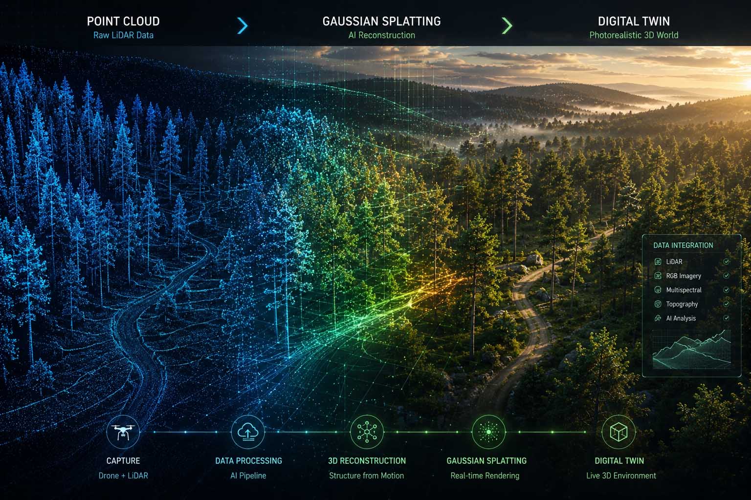
From Captured Data to Interactive Ecosystems
Visualization: The journey from LiDAR scans through AI reconstruction and digital twins to photorealistic real time environments for analysis and simulation | Image: © Ulrich Buckenlei | VISORIC GmbH
The image in this chapter illustrates the complete transformation of the data pipeline. Raw data is first captured, then analyzed, and finally integrated into a digital forest model. Individual point clouds evolve into a digital ecosystem that can be visualized, simulated, and continuously expanded.
This opens new possibilities for environmental research, forestry, and digital planning processes. Users can not only observe complex landscapes but actively analyze them and simulate future developments. The digital twin therefore evolves from a visualization into an interactive decision support platform.[24]
- LiDAR point clouds become usable 3D environments
- Gaussian Splatting creates photorealistic landscape models
- Digital twins combine analysis and visualization
- Real time platforms enable interactive simulations
- Forest ecosystems become virtually explorable and analyzable
The journey does not end with the digital forest. The future becomes especially exciting when individual digital twins are integrated into large scale environmental intelligence systems.
Hier ist die Übersetzung im unveränderten HTML Format:
Forest Intelligence on a Global Scale
The digitalization of individual trees and forest areas is only the first step. Over the long term, this gives rise to connected information systems capable of representing entire regions, countries, and ecosystems. Local forest twins evolve into a new form of planetary environmental intelligence. This is precisely where artificial intelligence, Earth observation, real time data, and digital twins merge into a shared infrastructure.[25]
Modern space programs, environmental organizations, and research initiatives are already working on platforms that bring together global environmental information. Satellite data, drone imagery, sensors, and AI analyses are combined into continuously updated models of natural systems. Forests are therefore no longer viewed as isolated areas but as part of complex ecological networks.
Particularly interesting is the ability to make changes visible across large spatial scales. Carbon storage, biodiversity, water resources, climate risks, and forest health can be analyzed within a shared digital model. This creates a new foundation for research, sustainability, and long term decision making processes.[26]
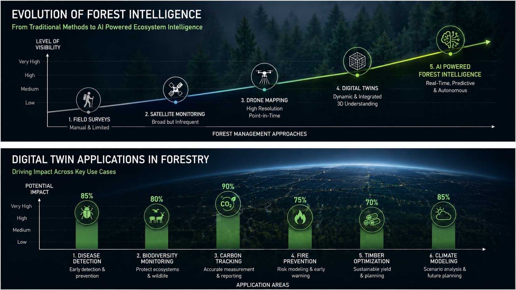
From Forest Monitoring to Global Environmental Intelligence
Visualization: The evolution from traditional forest monitoring to AI powered Forest Intelligence and globally connected digital ecosystems | Image: © Ulrich Buckenlei | VISORIC GmbH
The infographic in this chapter summarizes the development of recent years. Traditional field inspections evolved into satellite systems, then drone mapping, digital twins, and finally AI powered environmental platforms. At the same time, it highlights the most important fields of application for modern Forest Intelligence systems, from early disease detection to climate risk analysis.
For companies, research institutions, and public organizations, this creates a new perspective on natural resources. Decisions are increasingly based on current data, intelligent forecasts, and comprehensive digital models. Forest Intelligence is therefore becoming a central building block of future sustainability strategies.[27]
- Digital forest twins evolve into global information systems
- AI connects environmental monitoring and decision support
- Climate risks become visible at an early stage
- Biodiversity and carbon storage become measurable
- Planetary environmental intelligence emerges from connected data sources
Forest Intelligence today stands at a similar point to digital twins in industry a few years ago. What began with individual projects is increasingly developing into a global infrastructure for environmental monitoring, sustainability, and data based decisions. This development is also shown in the following video.
From Drone Scan to Forest Intelligence
The development of modern Forest Intelligence systems impressively shows how the relationship between technology and nature is changing. Forests are no longer simply mapped or documented. They are increasingly evolving into data driven ecosystems whose condition can be continuously captured, analyzed, and understood. Individual drone flights become digital twins, point clouds become intelligent models, and data becomes informed decisions.
The following video summarizes this development. It shows the path from data acquisition through LiDAR scanning and artificial intelligence to digital forest twins and real time platforms. From billions of measurement points, a new form of ecological intelligence emerges that makes natural systems visible, measurable, and analyzable.
Visualization: Drones, LiDAR sensors, artificial intelligence, digital twins, and real time platforms combine into a new generation of intelligent environmental technologies | Analysis, storyline, and editorial context: © Ulrich Buckenlei | VISORIC GmbH
The actual innovation does not lie in a single technology. What matters is the interplay of data acquisition, artificial intelligence, digital twins, and real time visualization. Only through this combination do systems emerge that continuously capture, interpret, and make environmental information usable for concrete decisions.
For forestry, environmental research, infrastructure operators, and public organizations, this opens up new opportunities. Forest health can be monitored, climate risks can be assessed, and long term developments can be identified at an early stage. At the same time, digital platforms are emerging that make complex ecological relationships more understandable and transparent.
The Munich based VISORIC expert team also views this development in the context of real time 3D, digital twins, artificial intelligence, and immersive data platforms. A particularly interesting question is how complex environmental information can be visualized in an understandable way in the future and integrated directly into operational decision making processes.
- Drones capture forests more precisely than ever before
- LiDAR creates digital twins of individual trees and landscapes
- AI detects risks, changes, and development trends
- Real time platforms connect analysis and visualization
- Forest Intelligence creates the foundation for sustainable decisions
The digitalization of natural ecosystems is still at an early stage. Yet it is already clear today how artificial intelligence, digital twins, and modern remote sensing are changing our ability to understand, protect, and sustainably manage forests over the long term.
From Forest Intelligence to Sustainable Decisions
AI powered Forest Intelligence is no longer a vision of the future. Digital twins, autonomous drones, LiDAR scanning, and real time analytics are already changing the way forests are monitored, protected, and managed today. What once relied on periodic field inspections is increasingly becoming a continuously updated digital representation of entire ecosystems. Forests therefore become measurable, analyzable, and in many areas even predictable.
For companies, research institutions, infrastructure operators, and environmental organizations, this creates entirely new possibilities. Forest health can be monitored continuously. Climate risks become visible earlier. Carbon storage can be assessed more precisely. Biodiversity can be analyzed across larger areas. At the same time, digital twins provide the foundation for simulations, planning processes, and long term sustainability strategies.

AI, LiDAR, digital twins, and real time 3D create a new generation of intelligent environmental platforms.
Visualization: Digital twins, artificial intelligence, real time 3D, and data driven decision platforms for environmental monitoring, sustainability, and intelligent infrastructures | Image: © Ulrich Buckenlei | VISORIC GmbH
The Munich based VISORIC expert team works at the intersection of digital twins, real time 3D, artificial intelligence, and immersive data visualization. We support companies and organizations in transforming complex data into understandable, interactive platforms for analysis, planning, training, and decision making.
Whether environmental monitoring, intelligent infrastructures, industrial digital twins, immersive training solutions, or real time visualization, the central challenge remains the same: preparing large amounts of data in an understandable way and translating them into usable insights.
- Digital twins for forests, infrastructure, and industrial facilities
- LiDAR, drones, and geospatial data platforms
- Real time 3D applications for analysis and simulation
- AI powered monitoring and decision systems
- Individual concepts for digitalization and sustainability initiatives
Contact the VISORIC expert team and discover how AI, digital twins, real time 3D, and intelligent data platforms can transform complex environmental and operational data into measurable added value.
Contact:
Email: info@visoric.com
Phone: +49 89 21552678
Sources and References
- Nature Scientific Reports, research on UAV based forest mapping, individual tree detection, and large scale vegetation analysis using drones and AI.
- FAO, Food and Agriculture Organization, Global Forest Resources Assessment and international standards for the digital monitoring of forest ecosystems.
- NASA Earth Observatory, Earth observation, remote sensing, and satellite data for forest monitoring, carbon storage, and climate research.
- ETH Zurich, research on airborne LiDAR, forest surveying, and high resolution data acquisition using drone systems.
- IEEE Geoscience and Remote Sensing Society, scientific work on LiDAR sensors, point clouds, and forest inventories.
- Nature Remote Sensing, research on capturing tree height, canopy structure, and biomass at individual tree level.
- NVIDIA Omniverse, platform for digital twins, simulation, and physically based real time environments.
- Epic Games Unreal Engine, real time 3D rendering, large world environments, and digital landscape models.
- Cesium, geospatial streaming and planet scale digital twins for real time visualization.
- Microsoft AI for Earth, AI models for analyzing vegetation conditions, biodiversity, and environmental changes.
- IEEE Computer Vision and Pattern Recognition, research on multispectral imagery, deep learning, and automated object detection.
- See source [5] for LiDAR based forest classification and multisensor data analysis.
- Google DeepMind, research on foundation models, pattern recognition, and data driven environmental analysis.
- Stanford Center for AI and Natural Systems, research on AI powered environmental observation and decision support.
- See source [7] for AI powered environmental modeling and ecological analysis.
- European Space Agency ESA, Copernicus Earth observation programs for climate, vegetation, and land use.
- United Nations Environment Programme UNEP, monitoring of natural ecosystems and climate risk assessment.
- See source [3] for carbon storage and global forest monitoring.
- NVIDIA Omniverse, real time data integration and continuous updating of digital twins.
- Unreal Engine World Partition, streaming of large landscape models and real time visualization.
- See source [10] for industrial real time simulation and digital twins.
- World Economic Forum, digital twins for natural ecosystems and data driven sustainability strategies.
- European Commission Destination Earth, digital twins of Earth for environment, climate, and resource management.
- See source [12] for large scale geospatial real time models.
- McKinsey & Company, digital twins and data driven decision making processes for sustainable infrastructure and resource management.
- Deloitte, AI driven digital twins and data based decision platforms.
- See sources [13] and [22] for digital ecosystems and planetary intelligence.
- Based on sources [1], [3], [10], [13], [22], and current research on digital twins, AI, and Forest Intelligence.
- Original video material based on publicly accessible demonstrations of LiDAR scanning, drone technology, Forest Intelligence, and digital twin workflows.
- Analysis, storyline, technological classification, and editorial contextualization: © Ulrich Buckenlei | VISORIC GmbH.
Contact Persons:
Ulrich Buckenlei (Creative Director)
Mobile: +49 152 53532871
Email: ulrich.buckenlei@visoric.com
Nataliya Daniltseva (Project Manager)
Mobile: +49 176 72805705
Email: nataliya.daniltseva@visoric.com
Address:
VISORIC GmbH
Bayerstraße 13
D-80335 Munich