

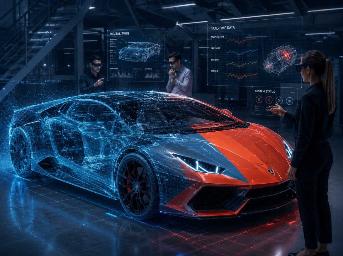
The boundaries between the physical and digital worlds are becoming increasingly blurred. Real-time 3D, Artificial Intelligence, Computer Vision, sensors, and Digital Twins are converging into spatial information systems that connect people, machines, and data within a shared environment for the very first time.
Visualization: The physical world is enhanced by intelligent digital layers. Real-time data, Digital Twins, and AI-powered analytics merge with real-world objects to create a new generation of spatial user interfaces for industry, engineering, and communication | Image: © Ulrich Buckenlei | XR Stager Online Magazine | VISORIC GmbH
Since the beginning of digitalization, people have worked with two separate worlds. The physical environment consists of machines, products, buildings, and people. The digital world is made up of software, 3D models, sensors, databases, and Artificial Intelligence. For decades, these two domains existed largely side by side. Information was displayed on screens and then mentally transferred to the real working environment.[1]
Today, this principle is changing fundamentally. Modern sensors continuously capture their surroundings, Computer Vision recognizes objects and movements in real time, Digital Twins virtually replicate physical systems, and Artificial Intelligence analyzes complex relationships within seconds. Spatial Computing combines these technologies into a shared spatial information layer in which digital content is precisely synchronized with the real world.[2]
This creates entirely new opportunities for collaboration between people, machines, and Artificial Intelligence. Information no longer appears isolated on a screen but exactly where it is needed. Maintenance instructions are displayed directly on machines, production data follows the physical workpiece, simulations merge with the real environment, and intelligent assistance systems support decision-making directly within the respective working context.
This development changes far more than the way information is displayed. It creates a shared spatial workspace in which physical objects, Digital Twins, and Artificial Intelligence communicate continuously with one another. Individual technologies evolve into an interconnected ecosystem that makes complex relationships easier to understand and supports workflows more intuitively.
The impact now extends far beyond industrial manufacturing. Engineering, architecture, logistics, healthcare, education, mobility, retail, and communication all benefit from the ability to combine physical and digital information in real time for the first time. Organizations gain new opportunities to simulate processes, make faster decisions, communicate knowledge more effectively, and enable people to collaborate more efficiently.
This marks the beginning of a new phase of digital transformation. The focus is no longer on individual technologies but on their intelligent synchronization. Only the precise interaction of real-time 3D, Computer Vision, sensors, Artificial Intelligence, and Digital Twins creates the spatial information systems that will shape many aspects of our professional and everyday lives in the years ahead.
- For the first time, physical and digital worlds are converging into a shared working environment.
- Computer Vision, sensors, real-time 3D, and Artificial Intelligence operate as an interconnected ecosystem.
- Digital information appears directly within its spatial context instead of on isolated screens.
- Industry, engineering, communication, and education all benefit equally from this development.
- The intelligent synchronization of physical and digital worlds forms the foundation of the next phase of digital transformation.
In this article, we explore how real-time 3D, Computer Vision, sensors, Digital Twins, and Artificial Intelligence are converging into a shared technology platform. You will discover why this development is fundamentally transforming industry, engineering, and communication, the role Spatial Computing plays in this transformation, and why the intelligent convergence of the physical and digital worlds is becoming one of the most significant innovations of the coming years.
When Physical and Digital Worlds Converge
Digitalization began with computers, networks, and software. Information was captured digitally, processed, and displayed on screens. At the same time, the physical world remained largely unchanged. Machines manufactured products, people worked with physical components, and buildings existed independently of their digital representations. For a long time, there was a clear separation between these two worlds. Digital information had to be interpreted by people before it could be applied to real-world situations.[3]
Today, this principle is changing fundamentally. Modern sensors continuously capture their surroundings, cameras recognize objects and movements in real time, Digital Twins reflect the current state of physical systems, and Artificial Intelligence analyzes millions of data points within moments. Isolated technologies are evolving into a shared spatial information platform where physical and digital content interact almost seamlessly in real time.[4]
The true innovation does not lie in any single technology. Only the precise combination of real-time 3D, Computer Vision, sensors, Artificial Intelligence, and Digital Twins makes it possible to permanently connect digital information with real-world objects, people, and environments. As a result, a digital model is no longer something that is simply viewed. Instead, it becomes an active part of the real working environment.
The following illustration demonstrates this transformation. While physical objects provide the real-world foundation, an intelligent digital layer extends their capabilities with live data, simulations, analytics, and Artificial Intelligence. Both layers merge into a shared information space in which digital content retains its spatial context and remains continuously synchronized with reality.
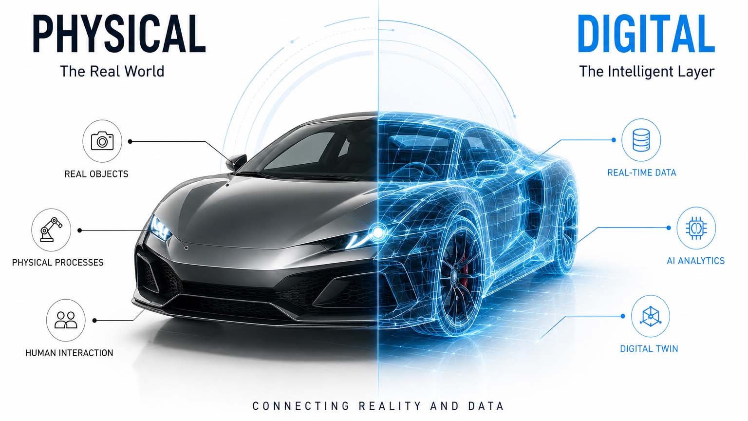
The infographic illustrates how physical objects and intelligent digital layers converge into a shared spatial information space. Real-time data, Digital Twins, and Artificial Intelligence enrich the physical world with contextual information, creating a new form of human-machine interaction.
Infographic: The convergence of the physical and digital worlds through real-time 3D, Computer Vision, Digital Twins, and Artificial Intelligence | Graphic: © Ulrich Buckenlei | XR Stager Online Magazine | VISORIC GmbH
This development is transforming far more than industrial processes. Communication, product development, architecture, logistics, healthcare, and education all benefit from preserving the spatial context of information. Employees no longer need to mentally transfer data between screens and reality. Instead, relevant information appears directly on the object, machine, or within a shared digital workspace. As a result, complex relationships become easier to understand and decisions can be made more quickly.
The transformation is particularly evident in industry. Digital Twins accompany products from the earliest stages of development, simulate production processes, monitor equipment during operation, and support maintenance with up-to-date condition data. At the same time, Artificial Intelligence continuously analyzes sensor data, detects anomalies, and provides context-aware recommendations. For the first time, this creates an information system that not only represents the physical world but actively understands and intelligently enhances it.
Spatial Computing serves as the connecting technology behind this transformation. It ensures that digital content remains permanently anchored within the correct spatial context and stays precisely synchronized with the physical environment. Information is no longer presented in isolation but becomes part of the real workspace itself. This intelligent synchronization forms the technological foundation for the next generation of digital applications and unlocks entirely new possibilities for industry, engineering, and communication.
- Physical and digital worlds are evolving into a shared spatial information platform.
- Computer Vision, sensors, real-time 3D, Digital Twins, and Artificial Intelligence operate as an interconnected ecosystem.
- Digital information retains its spatial relationship with the physical environment.
- Organizations gain a significantly deeper understanding of complex processes and can make better-informed decisions more quickly.
- Spatial Computing provides the technological foundation for the intelligent synchronization of the physical and digital worlds.
In the next chapter, we examine the key factor behind this transformation. Only when physical and digital information remains permanently and precisely synchronized does the spatial intelligence emerge that connects people, machines, and Artificial Intelligence within a shared working environment.
Why Perfect Synchronization Is Essential
The convergence of the physical and digital worlds can only succeed if both layers remain continuously synchronized. A Digital Twin must not only resemble its physical counterpart but also reflect its current state as accurately as possible. Positions, movements, sensor data, and environmental changes must be updated continuously. Only then can a shared understanding of reality emerge – one that people, machines, and Artificial Intelligence can access simultaneously.[5]
This synchronization is one of the greatest technical challenges of modern Spatial Computing systems. Cameras, depth sensors, LiDAR systems, GPS, inertial sensors, and industrial IoT platforms continuously provide new information about the physical environment. At the same time, Digital Twins, simulations, and AI models calculate updated states within milliseconds. Both information worlds must remain precisely aligned at all times.
Even minor deviations can disrupt the spatial relationship. If a digital object is positioned only a few centimeters incorrectly or information reacts with noticeable latency, users immediately lose confidence in the system. For this reason, modern Spatial Computing applications dedicate a significant portion of their computing power to the continuous synchronization of position, orientation, time, and sensor data.
The following infographic illustrates this intelligent synchronization process. Sensors continuously capture the physical environment and initially generate a point cloud. From this, a three-dimensional model is created and then semantically interpreted. Furniture, machines, tools, and people are recognized and assigned meaningful context. Only on this foundation can Digital Twins, Artificial Intelligence, and spatial user interfaces accurately connect digital information with the physical world.
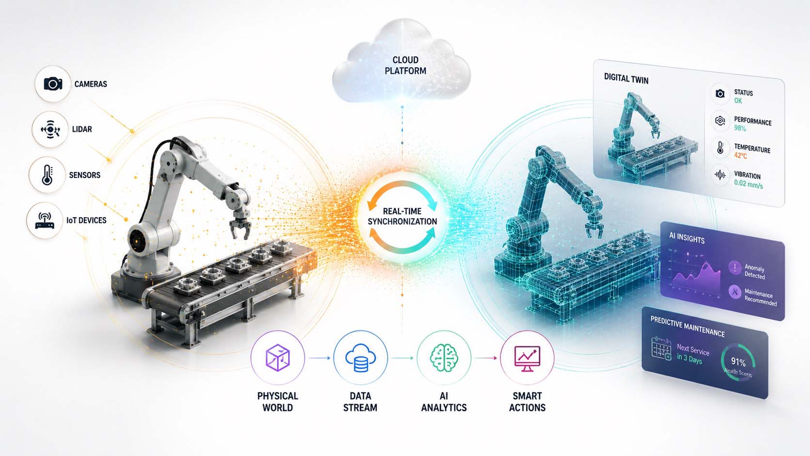
The infographic illustrates how modern Spatial Computing systems perceive their surroundings. Point clouds are transformed into three-dimensional models and subsequently interpreted through semantic analysis. Only this continuous synchronization enables the precise convergence of physical and digital information.
Infographic: From spatial scanning and 3D mapping to semantic understanding as the foundation of intelligent Spatial Computing systems | Graphic: © Ulrich Buckenlei | XR Stager Online Magazine | VISORIC GmbH
Synchronization is not limited to geometric information alone. Machine conditions, temperature values, energy consumption, material flows, and quality data are also continuously compared with the Digital Twin. The result is a living digital representation of the physical environment that immediately reflects changes while simultaneously enabling predictions about future developments.
This capability becomes particularly valuable in industrial applications. Maintenance activities can be prepared using current machine data, production processes can be monitored almost in real time, and safety zones can be adjusted dynamically. Artificial Intelligence therefore receives a far more reliable information foundation, enabling it to justify decisions more effectively and provide context-aware recommendations for specific situations.
The more accurately this synchronization functions, the more natural the collaboration between people and machines becomes. Digital information remains permanently anchored in the correct location, follows movements without perceptible delay, and preserves its spatial relationship even when people or machines are moving. What begins as a simple visualization evolves into a shared digital understanding of the physical world.
- Precise synchronization forms the foundation of every spatial user interface.
- Sensors, cameras, and IoT systems continuously update Digital Twins in real time.
- Point clouds, 3D mapping, and semantic analysis create a digital understanding of the environment.
- Only continuously synchronized information builds trust and enables natural interaction.
- The intelligent convergence of the physical and digital worlds creates the foundation for Industrial AI and autonomous systems.
In the next chapter, we explore how modern systems not only capture their surroundings but also understand them. Computer Vision, sensor fusion, and semantic analysis enable machines to interpret objects, spaces, and relationships in a way that increasingly resembles human spatial perception.
How Systems Understand Their Surroundings Spatially
Before digital information can permanently merge with the physical world, a system must first understand where people, machines, and objects are located. For humans, this happens almost unconsciously. Within just a few seconds, we recognize spaces, distances, directions of movement, and the positions of individual objects. Computers, by contrast, must develop this spatial understanding step by step.[7]
The process begins with different types of sensors. Cameras capture images, depth sensors measure distances, LiDAR systems generate point clouds, and motion sensors register every change in their own position. These data initially create a geometric representation of the environment. The system now understands the spatial arrangement of walls, machines, tools, and people.
In the next step, this information is continuously synchronized. The spatial model is updated whenever people move, machines change their position, or new objects enter the scene. This creates a stable spatial reference that allows digital content to remain permanently anchored in the same location, even while the user moves through the environment.[8]
The following infographic illustrates this process in four clearly defined steps. On the left, cameras, depth sensors, and LiDAR systems continuously capture the physical environment. This first generates a three-dimensional point cloud, followed by a spatial 3D model, and finally an intelligent world model that continuously synchronizes positions, movements, and relationships between individual objects. The visualization features a bright white background with premium-quality 3D elements and subtle gradients in blue, turquoise, orange, and violet. Large English labels such as “Reality Capture,” “Point Cloud,” “3D Mapping,” and “Spatial Understanding” enhance comprehension without overwhelming the illustration.
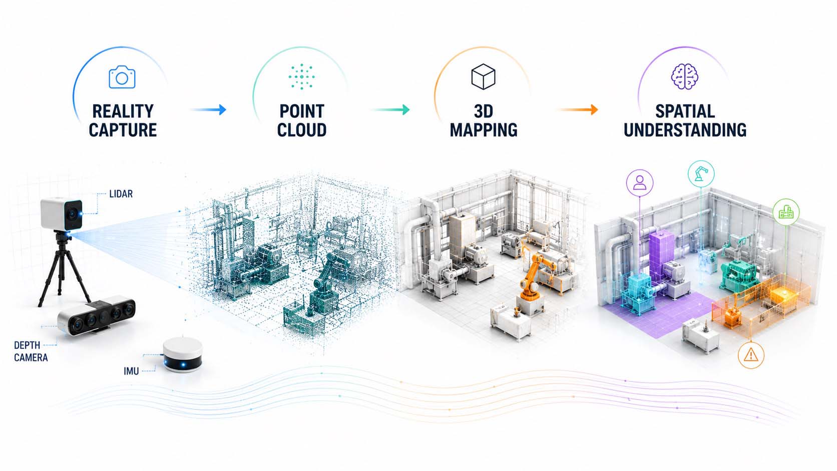
The infographic illustrates how modern Spatial Computing systems capture their surroundings, reconstruct them in three dimensions, and continuously synchronize them within a spatial world model. Only this stable world model enables the precise positioning of digital information inside real-world environments.
Infographic: From Reality Capture through Point Clouds and 3D Mapping to a spatial world model as the foundation of modern Spatial Computing systems | Graphic: © Ulrich Buckenlei | XR Stager Online Magazine | VISORIC GmbH
Once this spatial world model has been established, digital content can be permanently connected to physical objects. Maintenance instructions remain precisely anchored to a machine, navigation guidance follows the correct path through a factory, and virtual models retain their position regardless of the viewing angle. As a result, users experience digital information as if it were a natural part of the physical environment.
This spatial understanding also provides the foundation for all subsequent technologies. Digital Twins gain a precise relationship to the physical world, Artificial Intelligence can analyze spatial relationships, and autonomous systems navigate using the same shared information base. Individual sensor readings evolve into a consistent digital world model that can be used equally by people and machines.
- Sensors continuously capture positions, distances, and movements.
- Point clouds and 3D mapping provide the geometric foundation for spatial world models.
- Spatial reference systems ensure that digital content remains permanently and accurately anchored.
- All participants access the same shared spatial information base.
- Spatial Understanding provides the foundation for Digital Twins, Computer Vision, and Artificial Intelligence.
In the next chapter, this spatial world model evolves even further. A geometric 3D reconstruction becomes an intelligent Digital Twin that not only understands positions but also connects operating conditions, relationships, and real-time data within a unified spatial information platform.
When Digital Twins Come to Life
Once systems can capture and understand their surroundings spatially, the next stage of digital transformation begins. The Digital Twin evolves from a static 3D model into a continuously updated information platform. It no longer merely shows what a machine, production facility, or building looks like but reflects its current condition almost in real time. People, sensors, enterprise systems, and Artificial Intelligence all gain access to the same shared spatial information platform.[9]
For many years, Digital Twins primarily consisted of three-dimensional CAD models. They were used for planning, engineering, and visualizing individual products and facilities. Operational data, however, remained stored in separate systems. Sensor information resided in IoT platforms, maintenance records in service portals, and production metrics in Manufacturing Execution Systems. Employees had to switch between multiple applications to gain a complete understanding of the current situation.
Modern Digital Twins overcome this separation. They combine spatial models with continuously updated real-time data from sensors, automation systems, robotics, and industrial software. Temperature readings, energy consumption, machine conditions, material flows, and maintenance information are no longer displayed in isolation but are directly linked to their corresponding objects within the spatial model. A static 3D model thereby evolves into a living digital representation of the physical world.[10]
The following infographic illustrates this evolution. It shows the transition from a traditional CAD model through continuously synchronized live data to an intelligent Digital Twin that connects people, machines, Artificial Intelligence, and enterprise systems within a shared spatial world model.

The infographic illustrates the evolution of a Digital Twin from a traditional 3D model into an intelligent spatial world model. Real-time data, sensors, and Artificial Intelligence extend geometric representations into a continuously updated information platform for industry, engineering, and Spatial Computing.
Infographic: The evolution from CAD models through live data to intelligent Digital Twins as a shared spatial information platform | Graphic: © Ulrich Buckenlei | XR Stager Online Magazine | VISORIC GmbH
The true value of a Digital Twin, however, lies far beyond visualization alone. Its strength comes from integrating geometric models, real-time data, simulation models, and operational information within a shared spatial information platform. Any change to a physical machine can become visible within the Digital Twin almost immediately. At the same time, planned processes, maintenance activities, or optimizations can first be validated virtually before being implemented in real production.
This creates a common information foundation for everyone involved. Engineers view the same spatial data as service technicians, production managers, and AI-powered assistance systems. Everyone accesses the same current system status and makes decisions based on identical information. As a result, misunderstandings caused by inconsistent data or disconnected software systems are significantly reduced.
For industrial applications, this approach delivers substantial benefits. Sensors continuously provide measurements from machines and production systems while Artificial Intelligence analyzes these data, detects anomalies, and identifies optimization opportunities. Maintenance can be planned proactively, production processes monitored continuously, and operational changes immediately reflected within the Digital Twin. What begins as a visualization evolves into an intelligent decision support system that accompanies the entire lifecycle of a product or industrial asset.
Digital Twins become even more powerful when combined with modern simulation platforms. If an AI system detects unusual temperature developments, vibrations, or material deviations, these insights can immediately be visualized within the spatial model. Engineers can simulate alternative scenarios, evaluate the impact of planned changes, and validate optimizations within the virtual environment before applying them to reality. Decisions become more transparent while operational risks are significantly reduced.
Platforms such as Microsoft Azure Digital Twins and NVIDIA Omniverse already demonstrate the enormous potential of this approach. Digital Twins are rapidly becoming the central infrastructure for industrial simulation, robotics, Artificial Intelligence, and Spatial Computing. They connect planning, operations, maintenance, and optimization within a shared spatial information environment, enabling more efficient collaboration between people, intelligent machines, and autonomous systems.
The VISORIC expert team follows precisely this holistic approach. Reality Capture, Computer Vision, Digital Twins, real-time 3D, and Artificial Intelligence are combined into end-to-end Spatial Computing solutions that enable organizations not only to visualize products, machines, and processes but also to continuously analyze, simulate, and improve them together with people and AI.
- Digital Twins are evolving from static 3D models into continuously synchronized real-time platforms.
- Geometry, sensor data, simulations, and enterprise information merge into a shared information foundation.
- People, machines, and Artificial Intelligence access the same current operational status.
- Simulations and AI analytics support better-informed decisions throughout the entire product lifecycle.
- Digital Twins provide the foundation for modern Spatial Computing, Industrial AI, and Smart Factory solutions.
In the next chapter, Artificial Intelligence itself moves to the center of attention. Only when spatial world models are continuously analyzed, interpreted, and enhanced with intelligent recommendations does a new form of collaboration emerge in which people, AI, and digital systems combine their individual strengths within a shared spatial information environment.
Artificial Intelligence Becomes the Orchestration Layer
Digital Twins provide an accurate representation of the physical world. Sensors continuously capture new information, Computer Vision recognizes objects and movements, while spatial world models describe machines, buildings, and working environments in a structured way. True intelligence, however, only emerges when Artificial Intelligence combines all available data sources, interprets them, and derives context-aware decisions. In doing so, AI evolves into the orchestration layer of modern Spatial Computing systems.[11]
Earlier assistance systems primarily reacted to individual inputs or predefined rules. Modern AI systems, by contrast, simultaneously consider spatial positions, sensor data, the current operational status of equipment, work progress, and the specific context of use. As a result, information is not only displayed but also automatically prioritized and adapted to the current situation. A passive user interface evolves into an intelligent digital assistant.
This transformation is particularly evident through so-called Vision Models. They analyze camera images, recognize tools, machines, components, and people, and interpret their spatial relationships. At the same time, Large Language Models enable natural language understanding and support employees with complex tasks and questions. Modern Spatial Computing platforms increasingly integrate both capabilities directly on the end device, allowing many analyses to be performed almost in real time without requiring a permanent cloud connection.[12]
The following infographic illustrates this new role of Artificial Intelligence. At its center is an intelligent AI platform that continuously processes information from Computer Vision, sensors, Digital Twins, enterprise systems, and user interactions. Based on the shared spatial world model, it generates context-aware recommendations, automated workflows, and intelligent assistance functions for both people and machines.
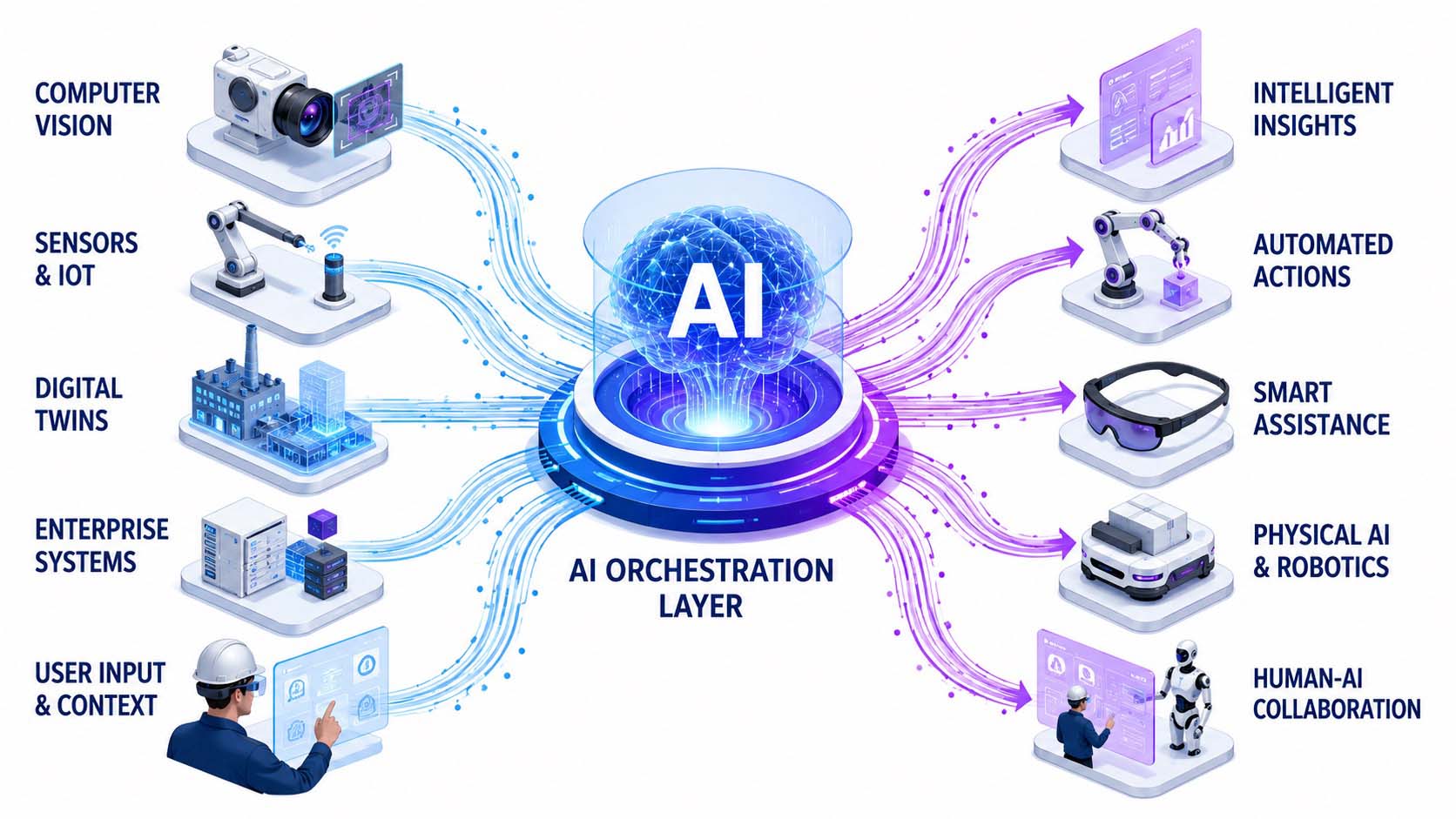
The infographic illustrates how Artificial Intelligence serves as the central orchestration layer, connecting spatial world models, Computer Vision, Digital Twins, sensors, and enterprise data. This creates context-aware assistance systems, automated decision-making, and intelligent industrial applications.
Infographic: Artificial Intelligence connects Computer Vision, Digital Twins, sensors, and Physical AI into a shared spatial decision platform | Graphic: © Ulrich Buckenlei | XR Stager Online Magazine | VISORIC GmbH
This fundamentally changes the role of Artificial Intelligence within industrial processes. AI no longer simply answers questions or generates content. Instead, it continuously observes spatial relationships, detects changes, evaluates risks, and supports people in making complex decisions. Maintenance activities can be prepared automatically, quality deviations detected at an early stage, and production processes optimized dynamically. Artificial Intelligence therefore evolves from a reactive tool into an active coordinator across the entire value chain.
At the same time, entirely new opportunities emerge through so-called Physical AI. Digital Twins serve as realistic training environments where robots, autonomous vehicles, and intelligent assistance systems can first learn and validate complex tasks in a virtual environment. Only after successful simulation are these capabilities transferred to physical machines. This significantly shortens development cycles, reduces risks, and accelerates the deployment of new automation solutions.
Employees also benefit directly from these advances in their daily work. Relevant information appears automatically in the appropriate context, work instructions adapt dynamically to each process step, and intelligent assistance systems recommend suitable actions before problems occur. Human expertise, real-time data, and Artificial Intelligence work together within the same shared spatial information platform.
For organizations, this development represents a fundamental shift in perspective. Artificial Intelligence does not replace people. Instead, it connects knowledge, data, and processes into a shared understanding of the current situation. It orchestrates information from a wide variety of sources, supports better decision-making, and creates the technological foundation for adaptive production systems, intelligent robotics, and the next generation of human-centric industrial applications.
- Artificial Intelligence is evolving into the central orchestration layer of spatial information systems.
- Vision AI, Large Language Models, and sensors together create a context-aware understanding of the current situation.
- Digital Twins provide the spatial foundation for intelligent assistance and automated decision-making.
- Physical AI uses realistic simulations to develop and validate autonomous systems.
- People, AI, and Digital Twins collaborate within a shared spatial information platform.
In the next chapter, the focus shifts back to people. Natural gestures, spatial user interfaces, and browser-based Spatial Computing technologies enable entirely new forms of collaboration in which communication, interaction, and shared digital workspaces seamlessly converge.
How Spatial Interaction Is Transforming Communication
The convergence of the physical and digital worlds is transforming not only industrial processes but also the way people communicate and collaborate. While traditional software primarily presents information on two-dimensional screens, modern Spatial Computing applications are evolving into shared spatial work environments. Digital content is placed exactly where it delivers the greatest value – directly within the users’ field of view and in the immediate context of their tasks.[13]
As a result, the user interface itself is changing fundamentally. Instead of menus, mouse pointers, or touchscreens, natural forms of interaction are taking center stage. Hands, gaze, speech, and movement become intuitive input methods that feel far more natural than conventional interaction concepts. Information appears exactly where people work, communicate, and make decisions, eliminating the constant need to shift attention between a screen and the physical environment.
Open web standards such as WebXR provide an important technological foundation for this transformation. They enable direct access to the spatial capabilities of modern XR devices through a standard web browser. Complementary standards for hand tracking accurately recognize gestures and finger movements, making natural interaction an integral part of modern user interfaces. As a result, cross-platform applications can run on a wide variety of devices without requiring dedicated software installations.[14]
The following infographic illustrates this transformation. People located in different places simultaneously access the same Digital Twin and collaborate within a shared spatial environment. Gestures, speech, gaze direction, and digital content merge into a natural form of collaboration in which spatial information can be understood, discussed, and edited by all participants at the same time.
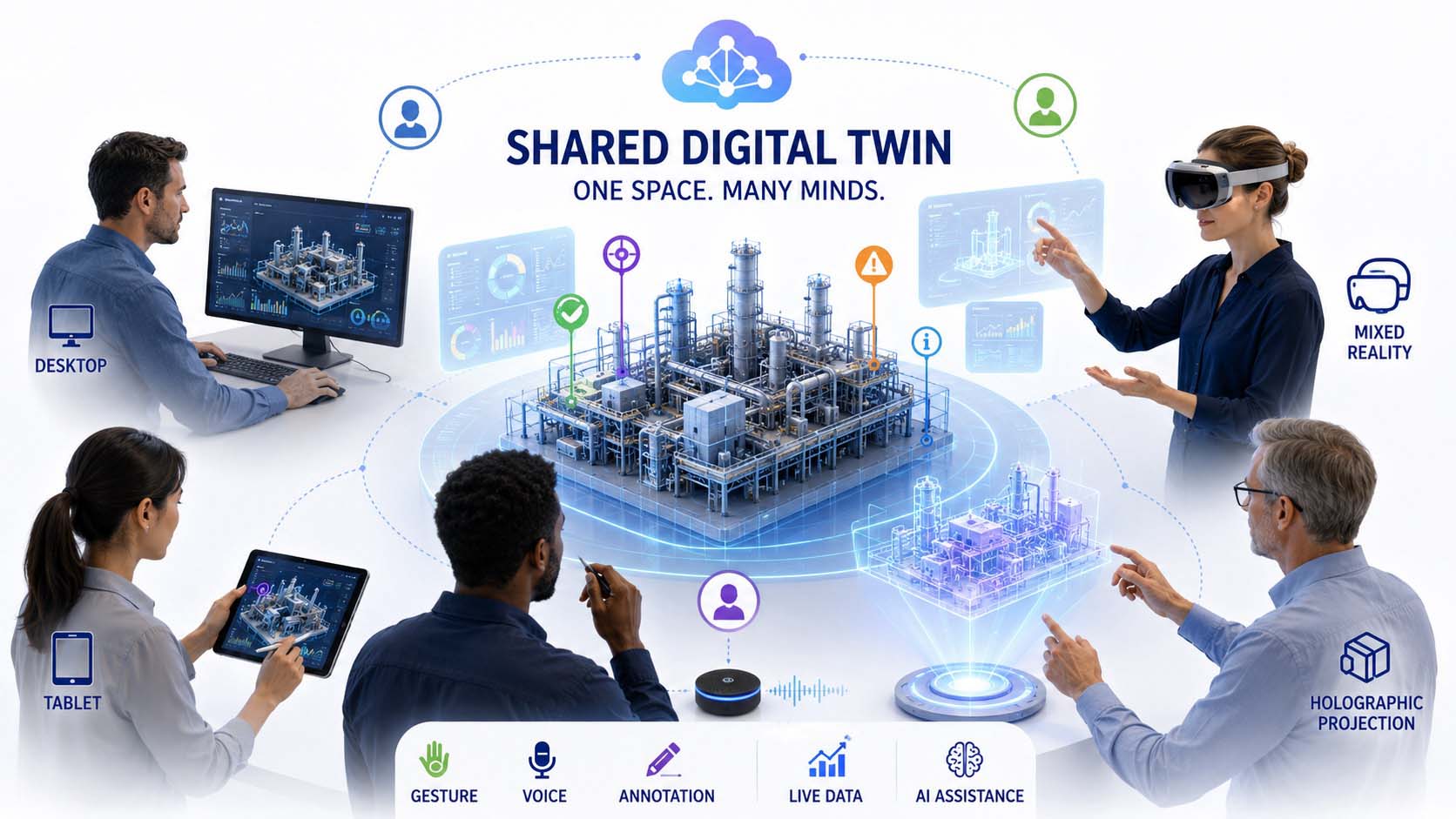
The infographic illustrates how spatial user interfaces connect people across different locations within a shared Digital Twin. Natural gestures, speech, and spatially anchored information create a new form of collaboration between people, machines, and Artificial Intelligence.
Infographic: Spatial collaboration through WebXR, hand tracking, and Digital Twins within shared Spatial Computing environments | Graphic: © Ulrich Buckenlei | XR Stager Online Magazine | VISORIC GmbH
For organizations, this development opens entirely new possibilities for collaboration. Experts can jointly analyze complex machinery even when they are located in different parts of the world. Maintenance activities can be discussed directly on the Digital Twin, training sessions become interactive experiences within realistic 3D environments, and international project teams work simultaneously on the same spatial information. Physical distance therefore becomes increasingly irrelevant.
Communication itself is also undergoing a fundamental transformation. Instead of exchanging lengthy technical descriptions or referring to static documentation, participants can point directly at objects, components, or individual process steps. Digital annotations, simulations, and live operational data become immediately visible within the shared spatial context. Misunderstandings are reduced, decisions can be aligned more quickly, and complex relationships become significantly easier to understand.
Industry, engineering, and service operations benefit particularly from these advances. Service technicians receive context-aware guidance directly at the machine, engineering teams discuss design modifications collaboratively within the Digital Twin, and production managers monitor operational conditions in real time inside a shared spatial workspace. At the same time, AI-powered assistance systems automatically present relevant information, consider the current stage of work, and provide context-sensitive recommendations whenever they are needed.
Communication therefore evolves from a simple exchange of information into a shared spatial experience. People, Digital Twins, and Artificial Intelligence collaborate within the same environment, access identical information, and develop a common understanding of complex relationships. Isolated applications give way to an interconnected platform for collaboration, knowledge sharing, and intelligent decision-making.
- Spatial user interfaces connect people, Digital Twins, and Artificial Intelligence within shared work environments.
- WebXR and hand tracking enable natural interaction directly inside the browser.
- Speech, gestures, and spatially anchored information increasingly replace traditional user interfaces.
- Remote collaboration evolves into shared real-time spatial collaboration.
- Communication becomes more visual, intuitive, and efficient because everyone works from the same spatial information foundation.
In the next chapter, we explore the tangible value these technologies are already creating today. From engineering and manufacturing to maintenance, training, and robotics, new industrial applications are emerging in which the intelligent convergence of the physical and digital worlds delivers measurable business value.
Where the Convergence Is Already Creating Value
Once the physical and digital worlds can be precisely connected, spatially understood, and coordinated through Artificial Intelligence, the key question becomes their practical value. This is exactly where it becomes clear that Spatial Computing, Digital Twins, and Industrial AI are no longer visions of the future. More and more organizations are integrating engineering, manufacturing, maintenance, and robotics within shared spatial information platforms, creating entirely new opportunities for planning, collaboration, and continuous optimization.[15]
The focus is not on a single technology but on the intelligent integration of a wide range of systems. CAD data, sensors, IoT platforms, enterprise software, real-time visualization, and Artificial Intelligence all access the same shared spatial information foundation. This creates a common digital understanding of complex processes that can be used simultaneously by people, machines, and intelligent assistance systems.
This transformation is particularly evident in modern industrial platforms. Companies such as Siemens and NVIDIA combine industrial software, physically accurate Digital Twins, and real-time simulation into a shared infrastructure for the Industrial Metaverse. Production facilities can be planned, simulated, monitored, and continuously optimized while every stakeholder works from the same up-to-date information.[16]
The following infographic highlights six key application areas where the intelligent convergence of the physical and digital worlds is already delivering measurable business value. Engineering, manufacturing, maintenance, training, robotics, and customer communication all access the same Digital Twin and use it as a shared spatial information platform for planning, collaboration, and intelligent decision-making.
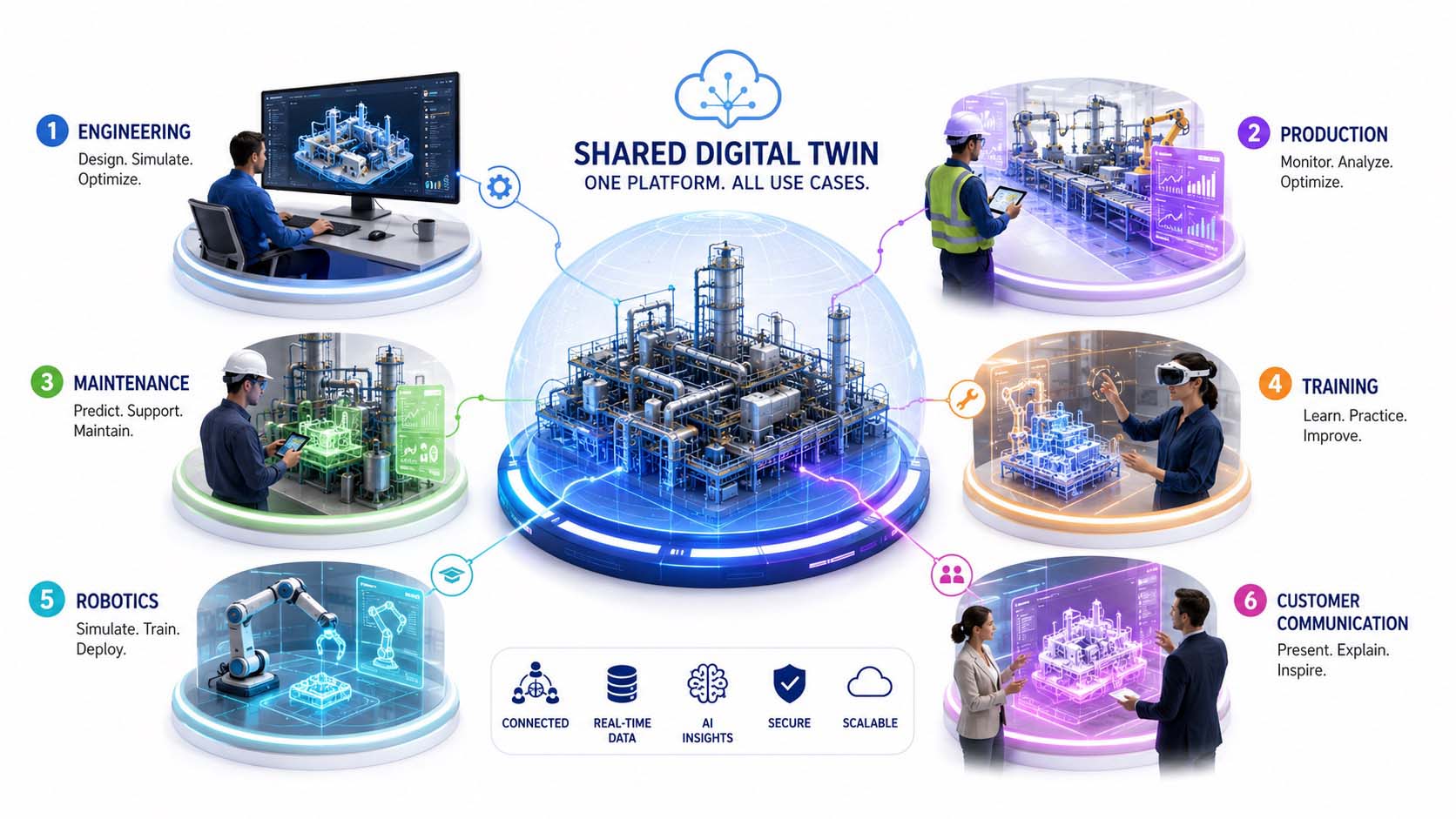
The infographic illustrates six key application areas where Spatial Computing, Digital Twins, and Artificial Intelligence already work together today. Engineering, manufacturing, maintenance, training, robotics, and customer communication all benefit from a shared spatial information platform.
Infographic: The most important industrial application areas of Spatial Computing, Digital Twins, and Industrial AI within a shared spatial information platform | Graphic: © Ulrich Buckenlei | XR Stager Online Magazine | VISORIC GmbH
In engineering, products, machines, and complete production lines can first be developed, simulated, and optimized virtually before physical prototypes are built. Design changes become immediately visible, their impact can be evaluated realistically, and development cycles are significantly accelerated.
In manufacturing, Digital Twins enable the continuous monitoring of equipment and production processes. Sensor data, quality metrics, and machine conditions are consolidated in real time, making it possible to detect deviations early, prevent downtime, and dynamically optimize production workflows.
Maintenance and service also benefit significantly from this development. Service technicians receive context-aware information directly at the machine, while Artificial Intelligence analyzes anomalies and recommends appropriate actions. Maintenance becomes more predictable, downtime is reduced, and complex industrial assets can be operated more efficiently.
Another important application area is education and workforce training. Realistic Digital Twins create interactive training environments where employees can safely learn new procedures and repeat complex scenarios as often as necessary. Valuable expertise is preserved and can be shared efficiently across multiple locations.
Robotics is advancing considerably through these technologies as well. Digital Twins serve as realistic simulation environments where autonomous systems are trained, tested, and validated before being deployed in real production environments. This reduces risks while significantly accelerating the development of new automation solutions.
Even customer communication is being transformed. Products, industrial facilities, and complex technical concepts can be presented collaboratively within interactive spatial models. Customers no longer experience products solely through static documentation or images but can explore functions, processes, and configuration options directly within the Digital Twin.
The intelligent convergence of the physical and digital worlds is therefore evolving into a shared platform that supports almost the entire industrial lifecycle. Development, manufacturing, operations, maintenance, training, and communication all rely on the same spatial information foundation. Decisions become more transparent, processes become easier to understand, and collaboration between people, machines, and Artificial Intelligence becomes significantly more efficient.
- Engineering uses Digital Twins to virtually develop and simulate complex products and industrial facilities.
- Manufacturing and maintenance benefit from real-time data, continuous monitoring, and AI-powered assistance.
- Interactive training environments accelerate workforce qualification while preserving valuable expert knowledge.
- Robotics uses Digital Twins for the simulation, validation, and development of autonomous systems.
- A shared spatial information platform connects the entire industrial lifecycle, from engineering and manufacturing to customer communication.
In the final chapter, we look ahead to the next stage of this evolution. Industry 5.0 places people back at the center, demonstrating how Artificial Intelligence, Digital Twins, and spatial information systems will not only automate processes but also empower people and create more resilient industrial systems.
The Future Belongs to Human-Centric Spatial Systems
The convergence of the physical and digital worlds is transforming not only technology but also the role of people within industrial processes. While earlier digitalization initiatives primarily focused on automation and efficiency, Industry 5.0 places increasing emphasis on collaboration between people, Artificial Intelligence, and intelligent machines. Technology is no longer intended to replace people but to empower them to make better decisions, make knowledge more accessible, and continuously improve working conditions.[17]
Spatial Computing is evolving into the central connection layer between the physical and digital worlds. Digital Twins provide a continuously updated understanding of complex systems, Computer Vision detects changes in real time, and Artificial Intelligence analyzes vast amounts of data within seconds. Together, these technologies create spatial information systems that deliver exactly the information people need in their specific working context.
This development opens up far-reaching opportunities for a more resilient industrial future. Manufacturing processes can be adapted more flexibly, supply chains can be monitored with greater transparency, and new production concepts can first be simulated virtually before being implemented in the real world. At the same time, organizations can use resources more efficiently, optimize energy consumption, and identify risks at an early stage. Digital Twins are therefore becoming a fundamental building block of sustainable industrial value creation.[18]
The following infographic illustrates the next stage of modern industry. People, Digital Twins, Artificial Intelligence, robotics, sustainable energy systems, and intelligent manufacturing work together within a shared spatial ecosystem. At the center is not the technology itself, but the human being, supported by intelligent assistance systems and working alongside machines to make informed decisions.
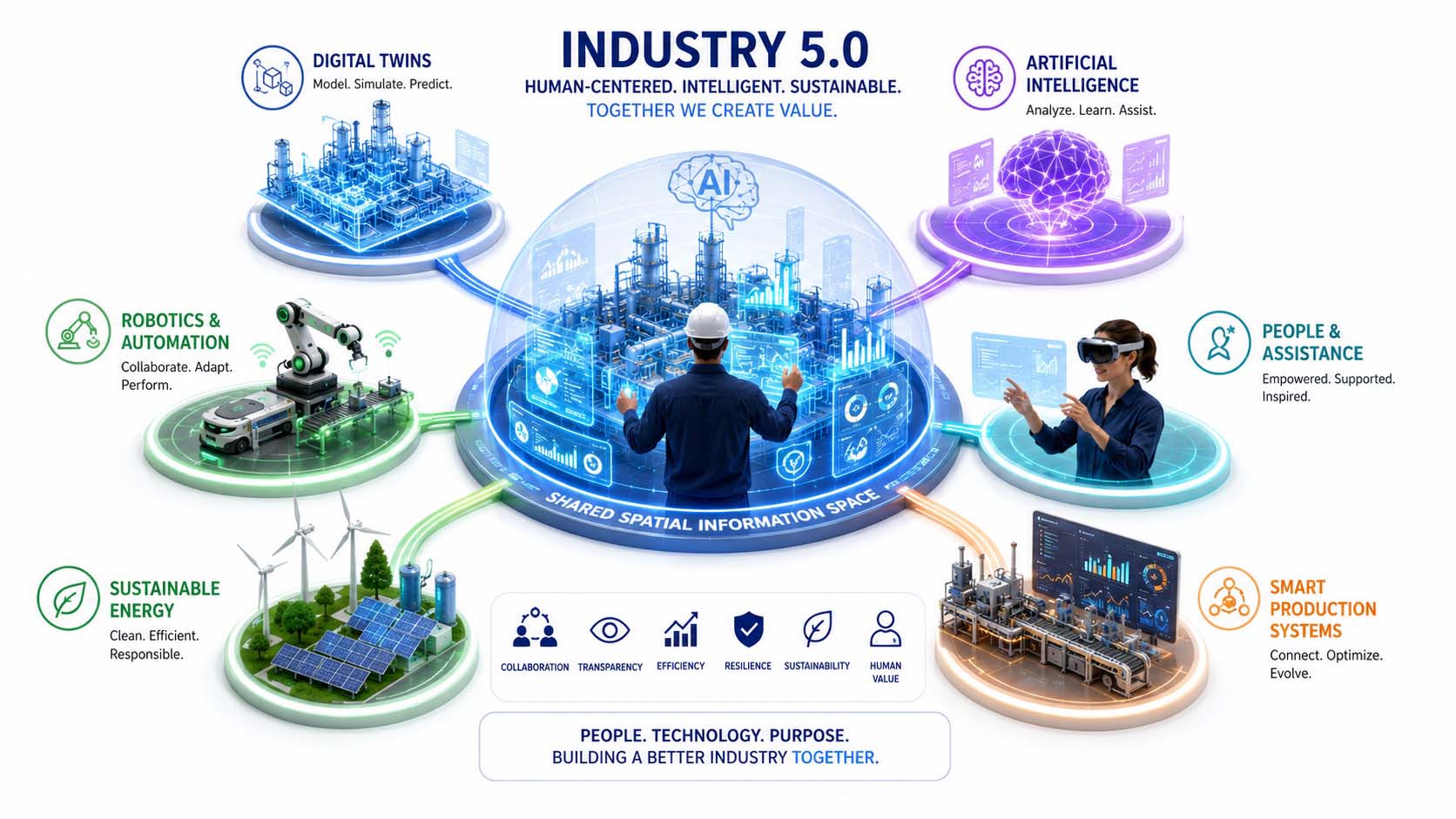
The infographic illustrates the vision of a human-centric Industry 5.0. Digital Twins, Artificial Intelligence, robotics, and sustainable manufacturing systems work together within a shared spatial information environment, supporting people in making complex decisions.
Infographic: Human-centric Industry 5.0 connects Digital Twins, Artificial Intelligence, robotics, and sustainable industrial systems within a shared spatial ecosystem | Graphic: © Ulrich Buckenlei | XR Stager Online Magazine | VISORIC GmbH
For organizations, this development represents a fundamental shift in perspective. Successful digital transformation will no longer be driven by isolated software solutions or stand-alone automation projects, but by interconnected platforms where people, machines, and intelligent systems access the same shared information. Spatial information models create transparency, foster collaboration across disciplines, and enable better decision-making throughout the entire lifecycle of products, industrial assets, and infrastructure.
Communication is evolving as well. Information is no longer managed in disconnected applications but presented within shared spatial models where it becomes immediately understandable. Engineering, manufacturing, service, training, and management all work from the same information foundation, enabling far more efficient collaboration. Knowledge remains permanently available and can be shared seamlessly across teams, organizations, and locations.
For the VISORIC team of experts, this transformation is at the heart of everything they do. By intelligently combining Reality Capture, Computer Vision, real-time 3D, Digital Twins, and Artificial Intelligence, VISORIC develops scalable Spatial Computing solutions that help organizations preserve knowledge, optimize processes, and connect people through intelligent technologies. The goal is not a more heavily automated industry, but a more capable and effective partnership between people and technology.
The coming years will reveal how rapidly this transformation accelerates. What is already clear today, however, is that the boundaries between the physical and digital worlds are steadily disappearing. Individual technologies are converging into a shared spatial information environment where people, Artificial Intelligence, and Digital Twins work together. This intelligent convergence forms the foundation of the next generation of industrial innovation, giving organizations entirely new opportunities to solve complex challenges in a sustainable, resilient, and human-centric way.
- Industry 5.0 places people at the center of intelligent industrial systems.
- Digital Twins, Artificial Intelligence, and Spatial Computing create shared spatial information platforms.
- Sustainability, resilience, and collaboration become the defining goals of industrial transformation.
- People, machines, and intelligent assistance systems make decisions based on the same shared information.
- The intelligent convergence of the physical and digital worlds forms the foundation of the next generation of industrial innovation.
The future of digital transformation is therefore not about generating ever more information. The real challenge is meaningfully connecting people, machines, and Artificial Intelligence within shared spatial information systems. Only when the physical and digital worlds work together seamlessly can the full potential of an intelligent, sustainable, and human-centric industry be realized.
When Flat Displays Become Spatial Worlds
The previous chapters have shown how the physical and digital worlds are gradually evolving into a shared spatial information platform. Sensors, Computer Vision, Digital Twins, and Artificial Intelligence provide the technological foundation for this transformation. The following video highlights another important building block of this evolution. It demonstrates how perspective-correct rendering can merge multiple flat displays into what appears to be one continuous three-dimensional environment.
At first glance, a futuristic spacecraft seems to fly freely through a real exhibition space. In reality, however, the virtual object never leaves the individual displays. Only the precise synchronization of perspective, geometry, motion, and lighting creates the illusion of a continuous three-dimensional space. Our brains no longer perceive separate screens but instead interpret them as a single shared spatial scene.
This is precisely what makes this demonstration so significant. It is not merely an impressive visual effect but a glimpse into how digital content can move beyond the limitations of individual displays. Flat screens evolve into windows that open onto shared digital spaces, becoming a new generation of spatial user interfaces for Spatial Computing, Digital Twins, and industrial collaboration.[19]
Original demonstration: LEDUSS (Instagram) | Technology analysis, narration, editorial commentary, and video editing: © Ulrich Buckenlei | XR Stager Online Magazine | VISORIC GmbH
The demonstration clearly shows that spatial perception does not depend exclusively on headsets or smart glasses. What truly matters is that digital content is geometrically aligned with the viewer’s position. Perspective, scale, and movement must be synchronized with precision so that the brain constructs a believable three-dimensional environment from multiple individual displays.
This creates entirely new opportunities for industrial applications. Control centers, operations rooms, engineering facilities, and digital command centers could consist of multiple synchronized displays working together to present a shared spatial Digital Twin. Complex production systems, infrastructure projects, and even entire factories could be explored and analyzed more intuitively without requiring every participant to wear a headset.
This approach also opens new possibilities for Spatial Computing itself. Spatial user interfaces will no longer be limited to individual devices. Smart glasses, projection systems, large-format displays, and mobile devices can present the same digital content simultaneously while accessing the same shared spatial information foundation. The result is a consistent digital workspace that can flexibly adapt to different usage scenarios.
This development becomes especially powerful when combined with Digital Twins. Perspective-correct rendering makes it possible to visualize machines, buildings, and complete production lines as spatial models that multiple people can view and discuss simultaneously. Decisions can be aligned more quickly, complex relationships become easier to understand, and spatial information can be communicated far more intuitively.
Over the long term, this approach could evolve into fully interconnected spatial work environments. Flat displays, Mixed Reality, projection systems, and intelligent smart glasses merge into a unified visual infrastructure. The Digital Twin is no longer confined to a single display but becomes a spatial information platform that people can truly experience while connecting people, machines, and Artificial Intelligence.[20]
- Perspective-correct rendering merges multiple displays into a single shared spatial scene.
- Our brains no longer perceive individual screens but instead experience one continuous digital environment.
- Spatial display architectures significantly expand the possibilities of Spatial Computing and Digital Twins.
- Engineering, control centers, and industrial operations benefit from more intuitive spatial visualization.
- The user interface of the future will no longer consist of individual displays but of intelligently connected spatial information systems.
The real innovation therefore does not lie in the display itself. It lies in the ability to synchronize digital information with geometry, perspective, and movement so precisely that individual screens become believable digital spaces. This evolution extends Spatial Computing into an entirely new dimension and demonstrates how the boundaries between the physical and digital worlds continue to dissolve.
The next generation of spatial user interfaces does not begin with smart glasses. It begins wherever digital content converges into a shared spatial environment.
From the Idea to a Successful Spatial Computing Platform
The technologies presented in this article are already evolving into a shared digital infrastructure for industry, engineering, and communication. However, Spatial Computing, Digital Twins, Computer Vision, real-time 3D, and Artificial Intelligence deliver their greatest value not as isolated solutions, but as intelligently connected systems. The real challenge is therefore not selecting individual technologies, but integrating them effectively into existing processes, data landscapes, and operational workflows.
Successful projects usually begin with a clearly defined use case. A pilot project in engineering, manufacturing, service, maintenance, product development, or technical communication provides the opportunity to validate new spatial workflows under real-world conditions. Organizations gain reliable insights into technical feasibility, user acceptance, integration effort, and business value before gradually scaling the solution across additional departments, locations, and business units.
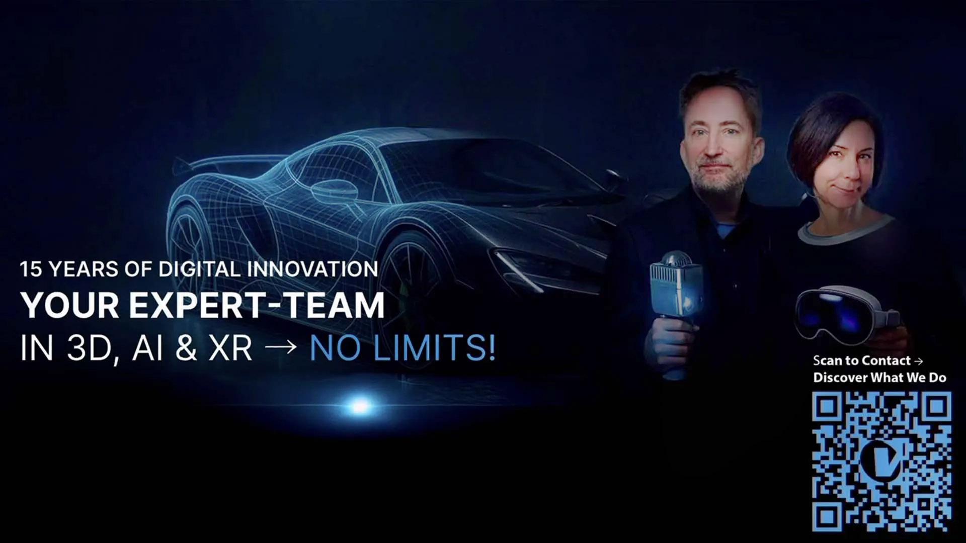
Successful Spatial Computing projects combine Digital Twins, Computer Vision, real-time 3D, and Artificial Intelligence into a shared spatial information platform for industry, engineering, and communication.
Visualization: Spatial Computing, Digital Twins, Computer Vision, real-time 3D, Industrial AI, and intelligent spatial user interfaces for industry, engineering, service, training, and communication | Image: © Ulrich Buckenlei | VISORIC GmbH
How to get started successfully:
- Identify a clearly defined use case with measurable business value.
- Integrate Digital Twins, Computer Vision, real-time 3D, and Artificial Intelligence into a unified spatial platform.
- Validate the pilot under real-world conditions and then scale it step by step across additional processes, locations, and business units.
Successful Spatial Computing projects do not begin with a specific hardware platform or a single AI model. They begin with a clear strategy, a scalable architecture, and a unified spatial information platform that intelligently connects people, machines, data, and Artificial Intelligence.
The Munich-based VISORIC team of experts supports organizations from the initial concept through productive deployment:
- Strategy, consulting, and solution design for Spatial Computing, Digital Twins, and Industrial AI.
- Development of interactive real-time 3D applications for web, desktop, mobile, and Augmented, Virtual, and Mixed Reality platforms.
- Integration of Computer Vision, Reality Capture, 3D scanning, and Digital Twins into existing engineering and manufacturing processes.
- Visualization of complex industrial facilities, products, and infrastructure using Unreal Engine, Unity, WebGPU, and modern web-based 3D technologies.
- Development, validation, and scaling of pilot projects into enterprise-wide international platforms.
Would you like to intelligently connect the physical world with digital information?
Whether your focus is Digital Twins, Spatial Computing, Computer Vision, interactive 3D visualization, Industrial AI, or spatial user interfaces, the Munich-based VISORIC team of experts helps transform innovative technologies into practical solutions with measurable business value. Together, we design scalable applications that integrate seamlessly into your existing system landscape and establish the foundation for the next generation of digital collaboration.
Contact:
E-mail: info@visoric.com
Phone: +49 89 21552678
Sources and References
- World Economic Forum. The Industrial Metaverse. How real-time 3D, Artificial Intelligence, and Digital Twins are enabling the next phase of industrial digital transformation.
- NVIDIA. Industrial Digital Twins and Omniverse. Platforms for synchronizing physical and digital worlds for simulation, planning, and intelligent industrial applications.
- Apple Developer. visionOS and Spatial Computing. Technologies for integrating digital content with the physical environment.
- Khronos Group. OpenXR 1.1 Specification. Open standard for Virtual Reality, Augmented Reality, and Mixed Reality.
- Microsoft Mixed Reality. Spatial Anchors. Spatial anchoring of digital content within real-world environments.
- NVIDIA Omniverse Digital Twins. Connecting physically accurate 3D models with sensors, IoT systems, and real-time data.
- Khronos Group OpenXR. XrSpace and spatial reference systems for positioning virtual content within physical environments.
- Apple Developer ARKit. Spatial Accessory Tracking for tracking the position and orientation of physical objects.
- Microsoft Azure Digital Twins. Modeling connected physical environments using real-time data, IoT, and interactive 3D visualization.
- NVIDIA Omniverse Digital Twins. Physically accurate virtual replicas of industrial assets, factories, and processes continuously synchronized with the real world.
- Qualcomm Snapdragon Reality Elite. On-device Artificial Intelligence, Vision Models, and Spatial Computing for intelligent spatial applications.
- NVIDIA Omniverse. Development platform for Physical AI, industrial Digital Twins, and robotic simulation.
- World Wide Web Consortium. WebXR Device API. Browser-based access to Virtual Reality and Augmented Reality devices and their sensors.
- World Wide Web Consortium. WebXR Hand Input Module. Standardized hand and gesture tracking for natural spatial interaction.
- Siemens and NVIDIA. Industrial Metaverse and real-time Digital Twins for industrial automation, engineering, and manufacturing.
- NVIDIA Robotics Simulation. Simulation, training, and validation of Physical AI robots within physically accurate Digital Twins.
- European Commission. Industry 5.0. A sustainable, resilient, and human-centric industry of the future.
- European Commission. Industrial Technologies Roadmap on Human-Centric Research and Innovation for the Manufacturing Sector.
Contact Persons:
Ulrich Buckenlei (Creative Director)
Mobile: +49 152 53532871
Email: ulrich.buckenlei@visoric.com
Nataliya Daniltseva (Project Manager)
Mobile: +49 176 72805705
Email: nataliya.daniltseva@visoric.com
Address:
VISORIC GmbH
Bayerstraße 13
D-80335 Munich