Spatial 3D data as a basis for decision making: Data glasses make complex CAD based structures tangible at a 1:1 scale and shift decisions from abstract screens into the real spatial context of industrial processes.
Entrepreneurial decisions are often made on the basis of abstract models, technical drawings, and two dimensional representations. Even when this information is precise, its interpretation often remains detached from the real context of use. This is exactly where a fundamental shift begins. As soon as data becomes spatially usable, perception, understanding, and decision making change. Information is no longer merely viewed, but experienced, validated, and understood in direct context.
Spatial 3D data as a success factor for enterprises
Mixed reality glasses, also referred to as AR glasses or spatial computing headsets, turn 3D CAD data into a photorealistic spatial experience directly at the workplace. What was once perceived primarily as visual support is increasingly evolving into a strategic decision making tool. Spatially usable 3D data is neither a gimmick nor a novelty. It is a measurable success factor that helps companies shorten development cycles, detect errors early, and achieve annual savings in the millions.
The decisive leverage lies in the fact that the same data can be used across the entire value chain. A single well prepared 3D dataset no longer serves construction alone, but becomes a shared foundation for development, training, service, and marketing. Decisions become more consistent, coordination more efficient, and knowledge is no longer isolated within individual departments.
- Development → Spatially usable 3D models enable early reviews, faster iterations, and well founded design decisions directly at a one to one scale.
- Training → Complex products can be conveyed realistically, independent of physical access to machines or prototypes.
- Service → Maintenance workflows, accessibility, and repair steps can be reviewed and trained in advance, significantly reducing downtime and travel costs.

From three view drawing to spatial use: A clear technical drawing forms the abstract foundation from which a high quality 3D model emerges that can later be viewed and understood in real space.
This approach is particularly effective where errors are costly and decisions have long term consequences. In development, the need for physical prototypes decreases. In training, onboarding times are shortened while knowledge quality improves. In service, operations can be better prepared, reducing downtime and enabling more efficient use of resources. These effects add up to significant economic benefits across the entire product lifecycle.
In addition, spatial 3D data also unfolds its impact in marketing. High quality, technically accurate models can not only be used in mixed reality glasses, but can also be distributed across additional channels. Web based 3D applications, interactive product configurators, trade fair visualizations, or classic marketing media all access the same data core. This ensures consistency, reduces production effort, and increases visual quality across all touchpoints.
The success of this approach is based on clear principles: clean data structures, an end to end 3D pipeline, and the ability to prepare content for different devices and usage scenarios. This is exactly where it is decided whether spatial data remains a short term effect or becomes a sustainable competitive advantage.
In the next chapter, we therefore go one step deeper and show how existing CAD data is transformed into performant, flexible, and cross channel usable 3D assets, and which requirements companies should place on technology, processes, and partners.
From CAD Data to Performant 3D Assets
The central graphic of this chapter illustrates the core of what makes spatial 3D data effective within an enterprise. It is not about individual models or tools, but about an end to end pipeline that transforms CAD data into performant, flexible, and cross channel usable 3D assets. Only when this chain is properly established can spatial applications in development, training, service, and marketing unfold their economic value.
At the beginning are classic CAD data. They are highly precise, technically accurate, and rich in detail, but not designed for real time, mixed reality, or web applications. Without targeted preparation, they are too complex, too heavy, and too inflexible for use outside of engineering. The first decisive step is therefore to structurally analyze these data and prepare them for downstream usage scenarios.
- CAD Data → Technically precise source data from construction and engineering.
- 3D Optimization → Polygon reduction, texture optimization, and clean LOD structures.
- Creation of Assets → Building reusable, format independent 3D assets.
- Distribution & Use → Deployment in mixed reality, web 3D, and additional digital channels.
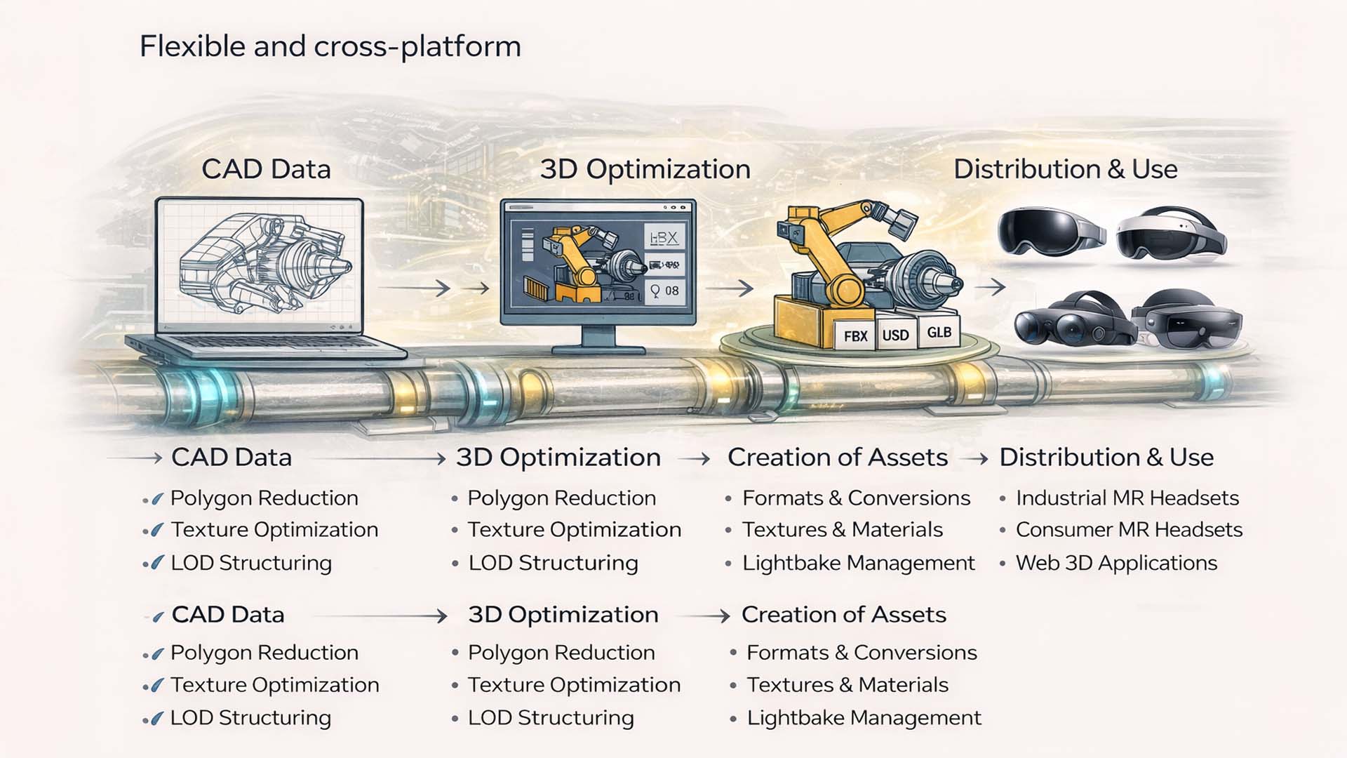
From CAD Data to Performant 3D Assets: An end to end pipeline transforms technical construction data into flexible, performant, and cross channel usable 3D content.
Visualization: © Visoric Research Lab 2025 | Conceptual representation of an industrial 3D pipeline for mixed reality, web 3D, and digital product communication. Editorial: Ulrich Buckenlei.
The 3D optimization phase determines whether a model will be usable later or not. Polygon reduction, texture optimization, and LOD structures ensure that complex geometries can be rendered performantly without losing their technical meaning. This step is essential for use on mixed reality glasses, spatial computing headsets, and web based 3D applications.
During the asset creation phase, the optimized models are converted into clearly defined formats. Formats such as FBX, USD, or GLB make it possible to use the same content across different platforms. Materials, lighting information, and interaction logic are designed to function consistently, regardless of whether the asset is later used in an industrial MR application, on a consumer headset, or on the web.
The final step is distribution. This is where the strategic value of the pipeline becomes particularly clear. A centrally managed 3D asset pool supplies development, training, service, and marketing simultaneously. While engineers conduct spatial reviews using the same data, training teams use the content for instruction, service departments for maintenance scenarios, and marketing for product communication. The effort of multiple asset creation is eliminated, consistency increases, and the investment in 3D content amortizes across multiple channels.
In the next chapter, we examine which organizational and technological prerequisites must be met for this pipeline to function sustainably. This includes data quality, process integration, and the role of experienced partners in implementing spatial 3D strategies in an industrial context.
The organizational and technological foundations of spatial 3D strategies
The central graphic of this chapter visualizes why spatial 3D initiatives often fail in practice or succeed in the long term. It does not show a single technology, but rather an interplay of data quality, process integration, and experience. Only when these three pillars are connected does a performant 3D pipeline emerge that functions reliably and remains scalable in everyday industrial use.
On the left side of the graphic, data quality stands as the foundation. CAD data quality represents the technical truth of a product, but for spatial applications, data must deliver more than pure geometry. CAD conformance, detailed metadata, and clean hierarchies ensure that models can be processed automatically, converted into variants, and distributed across different usage scenarios. Without this foundation, breaks occur, manual rework increases, and long term operational costs rise.
- CAD Conformance → Unified standards and clean model structures.
- Detailed Metadata → Clear information on components, functions, and variants.
- Clean Hierarchies → Logical assemblies and consistent naming.
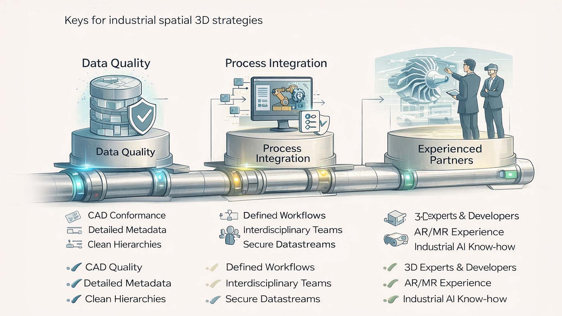
Foundations for Spatial 3D Success: Data quality, process integration, and experienced implementation partners together form the basis for stable, scalable spatial 3D pipelines in an industrial context.
Visualization: © Visoric Research Lab 2025 | Conceptual representation of the organizational and technological prerequisites for spatially usable 3D strategies. Editorial: Ulrich Buckenlei.
At the center of the graphic, process integration is shown as the connecting layer. Spatial 3D data only unfolds its value when it is seamlessly embedded into existing enterprise processes. Defined workflows create clear handovers between engineering, IT, training, service, and marketing. Interdisciplinary teams ensure that requirements from practice, safety, and usability are brought together early. Secure data streams ensure that 3D content is reliably available, versioned, and delivered where it is needed.
- Defined Workflows → Clear handovers between departments and systems.
- Interdisciplinary Teams → Collaboration between engineering, IT, and business units.
- Secure Datastreams → Controlled data flows across all channels.
On the right side, the graphic highlights the role of experienced partners. Expert partners combine the disciplines that spatial 3D strategies require today. 3D experts and developers ensure performant assets and stable real time implementation. AR and MR experience ensures that spatial applications are not only technically functional, but also intuitive to use in real working environments. Industrial AI know how increasingly complements this pipeline through automation, variant logic, and intelligent data processing, enabling companies to scale without manually rebuilding every asset.
- 3D Experts & Developers → Technical implementation and optimization of performant content.
- AR/MR Experience → User centered spatial workflows for everyday industrial use.
- Industrial AI Know how → Automation, variant logic, and intelligent processing.
Taken together, these three pillars illustrate why spatial 3D initiatives should not be viewed as short term innovations. They are part of a long term digital strategy that sustainably transforms product development, knowledge transfer, and decision making processes. Companies that establish these foundations early gain a structural advantage that extends far beyond individual applications.
In the next chapter, we shift our focus to concrete application scenarios. There, it becomes clear how spatial 3D data is practically used in development, training, service, and marketing, and which measurable effects it delivers in everyday industrial operations.
Concrete application scenarios for spatial 3D applications in the enterprise
The central graphic of this chapter condenses what spatial 3D strategies actually deliver in everyday industrial operations. It shows four application areas that often coexist in companies and are connected through a shared 3D pipeline: development, training, service, and marketing. The decisive point is not the individual scenario, but the fact that all areas access the same consistent 3D data core.
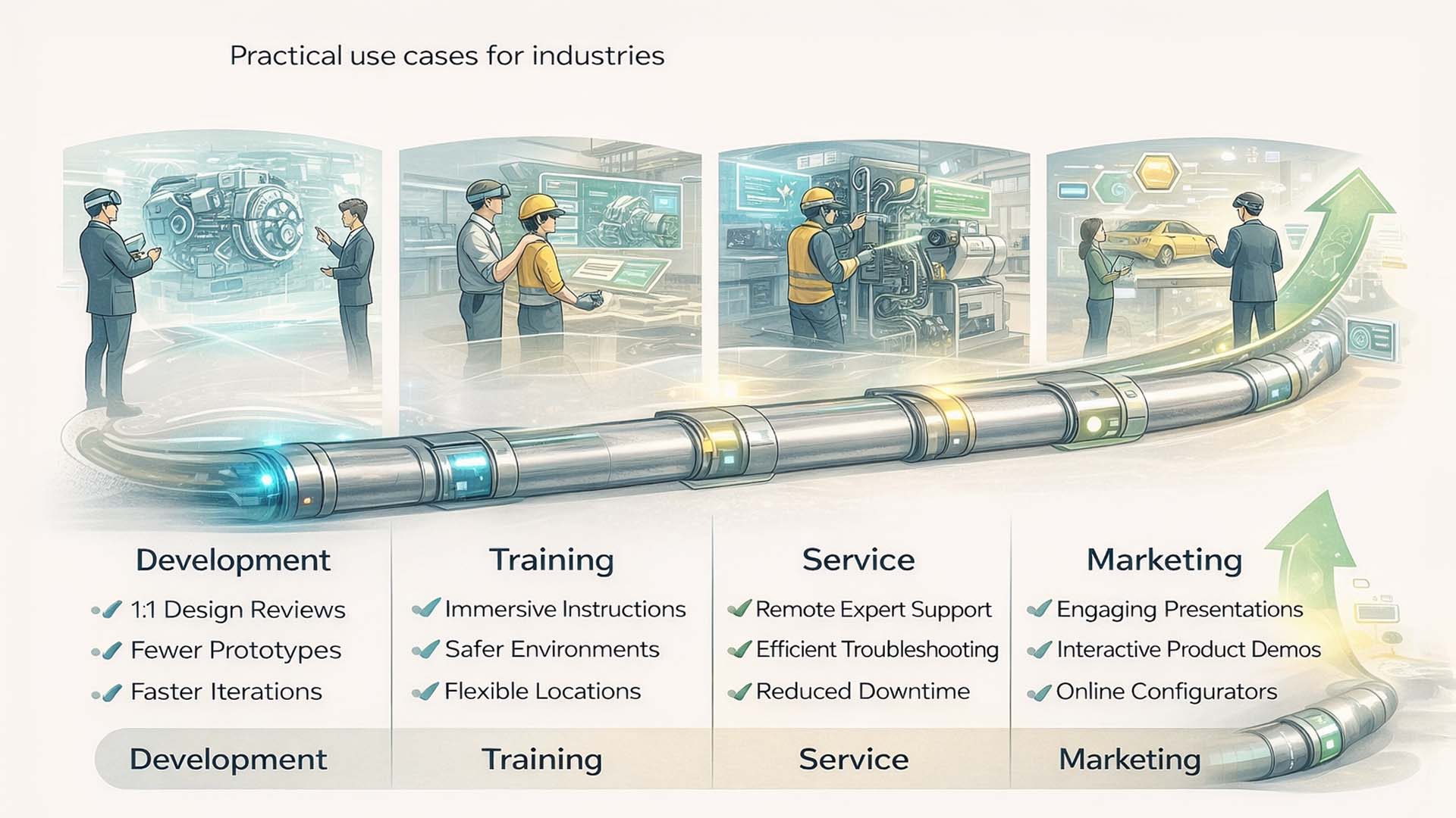
Driving Success with Spatial 3D Applications: An end to end 3D pipeline connects development, training, service, and marketing, making spatial data a company wide success factor.
Visualization: © Visoric Research Lab 2025 | Conceptual representation of industrial use cases for spatial 3D applications. Editorial: Ulrich Buckenlei.
In development, the graphic shows how spatial 3D models enable design reviews at a one to one scale. Engineering teams no longer discuss abstract geometries, but real proportions, distances, and accessibility. This reduces the need for physical prototypes, accelerates iterations, and leads to more robust design decisions in early project phases.
The second field is training. Here, the same 3D data is used to create immersive training environments. Employees can learn complex machines, processes, or maintenance steps realistically, independent of location or availability of real equipment. The graphic illustrates how training becomes safer, more flexible, and more scalable, while onboarding times and error rates decrease.
In the service context, the graphic shows the use of spatial 3D data directly at the point of operation. Technicians receive contextual information, step by step instructions, or remote support from experts. This leads to faster diagnostics, shorter downtime, and more efficient use of expert knowledge across locations.
The fourth area is marketing. Here, spatial 3D models are used to present products interactively. Whether at trade fairs, in digital showrooms, or as web based configurators, the same data enables consistent, high quality product communication across all channels. The graphic clearly shows that marketing is not created independently of engineering, but directly benefits from the technical data foundation.
The connecting pipeline at the bottom of the graphic represents the strategic core of this approach. Once created and properly prepared, 3D assets are not produced multiple times, but intelligently reused. This reduces costs, increases consistency, and makes investments in 3D content economically sustainable over the long term.
In the next chapter, we look ahead. There, we examine how spatial 3D applications continue to evolve through real time technologies and artificial intelligence, and which strategic decisions companies should make today to leverage this development sustainably.
Spatial 3D of the future: When real time and artificial intelligence converge
The central graphic of this chapter shows where spatial 3D applications in an industrial context are heading. At the center is the concept of Spatial 3D of Tomorrow, an interplay of real time technologies, powerful hardware, and artificial intelligence that transforms spatial data from a purely visual medium into an active, learning system.

Spatial 3D of Tomorrow: Real time rendering, AR glasses, and industrial AI merge into an intelligent spatial system for analysis, interaction, and decision making.
Visualization: © Visoric Research Lab 2025 | Conceptual representation of the next development stage of spatial 3D applications. Editorial: Ulrich Buckenlei.
On the left side of the graphic, the evolution of real time 3D graphics is depicted. Powerful rendering engines now enable photorealistic visuals with low latency. Advances in AR glasses, spatial computing headsets, and haptic interfaces ensure that spatial content is not only visible, but intuitively operable. Interaction takes place directly in space, no longer through abstract input devices.
At the center of the graphic, these technologies converge into a continuous real time system. Spatial 3D models are not loaded statically, but updated continuously. Sensor data, user input, and system states flow in real time. Spatial 3D thus becomes a dynamic environment in which digital content adapts to context, situation, and usage.
The right side of the graphic illustrates the role of industrial AI. Artificial intelligence analyzes 3D data, usage behavior, and process information. This enables new capabilities such as predictive maintenance, automated variant generation, or AI assisted decision support. 3D models are no longer used solely for visualization, but become training foundations for learning systems.
The connecting arrow structure of the graphic highlights the direction of this development. Spatial 3D becomes the integration point between humans, machines, and data. Decisions are no longer formed solely through human interpretation, but through collaboration with intelligent systems that recognize patterns, simulate scenarios, and derive recommendations.
This outlook makes it clear that spatial 3D applications are not at the end of their evolution, but at the beginning of a new phase. Companies that invest today in clean data structures, real time capability, and AI integration create the foundation for sustainable competitive advantages.
In the next and final chapter, we summarize the key insights and outline which strategic steps companies should take now to successfully and sustainably integrate spatial 3D technologies into their organizations.
From technology adoption to sustainable competitive advantage
At the center of this chapter is deliberately a different type of visualization. Unlike the previous process and pipeline graphics, it does not describe a linear sequence, but a strategic system. A stable core surrounded by interconnected success factors that determine whether spatial 3D technologies remain short term experiments or become a lasting success factor for an enterprise.
The graphic presents successful 3D integration as a central field of impact. Four essential capability areas extend from this core. Each area is equally important. Weaknesses in any one area immediately limit the effectiveness of the others. The goal of this chapter is to translate this visual logic into concrete, strategically usable principles.

Anchoring spatial 3D strategies sustainably: Data quality, expertise, scalability, and long term planning together form the foundation for measurable economic value.
Visualization: © Visoric Research Lab 2025 | Conceptual framework for the sustainable introduction of spatial 3D technologies in industry. Editorial: Ulrich Buckenlei.
The foundation is data quality. Cleanly structured, consistent, and well documented CAD data forms the basis of any spatial 3D strategy. Without clear naming, reliable metadata, and technically correct geometry, even the most advanced XR technologies cannot generate dependable value. High data quality ensures that spatial models can be used with confidence across development, training, service, and communication.
Equally central is expertise. Spatial 3D solutions do not emerge from software alone, but from interdisciplinary teams that combine 3D development, AR and MR experience, process understanding, and industrial domain knowledge. Experienced partners understand both technical realities and organizational frameworks. This is often the decisive difference between impressive demonstrations and scalable, economically effective solutions.
Another core factor is scalability. A sustainable 3D strategy ensures that once created, 3D assets can be used across multiple platforms. Mixed reality glasses, desktop applications, mobile devices, web solutions, and marketing channels all access the same data core. This reduces costs, increases consistency, and makes investments economically viable in the long term.
The fourth pillar is long term planning. Spatial 3D technologies only unfold their full value when embedded in a clear roadmap. Governance, security concepts, phased rollout, and continuous optimization transform pilot projects into a stable digital infrastructure that sustainably supports decision making, training, and collaboration.
- Data quality → Clear CAD structures, reliable metadata, and clean standards build trust.
- Expertise → Interdisciplinary teams connect technology, processes, and industrial reality.
- Scalability → A single 3D asset approach serves development, training, service, and marketing across all platforms.
- Long term planning → Strategic roadmaps make innovation sustainably effective.
Together, these factors form a stable system. When aligned, spatial 3D technologies evolve from isolated innovation projects into a structural capability. Companies benefit from lower costs, faster decisions, more efficient training, better service, and consistent communication across all channels.
With this summary, the focus shifts from strategy to application. In the following video chapter, we show how these principles work together in practice and how spatial 3D environments are used in real industrial scenarios.
From concept to reality: The mixed reality CAD pipeline in practice
The following video shows the practical implementation of what has been conceptually described in this article. It visualizes a complete mixed reality CAD pipeline, from existing construction data to spatially usable, photorealistic digital twins. The focus is not on technology as an end in itself, but on its application in a real industrial context.
It demonstrates how complex CAD data is transformed into a performant, interactive 3D environment that can be used immediately in mixed reality headsets and on accompanying devices. The models appear at a one to one scale, can be intuitively manipulated, and enable decisions directly at the workplace, in real space rather than on an abstract screen.
The video was conceived and produced by Ulrich Buckenlei and the Visoric expert team. The software solution shown is developed in house and is part of a modular platform specifically designed for industrial requirements related to CAD, spatial computing, and digital twins. It combines data preparation, real time 3D, interaction logic, and multi device deployment into a consistent pipeline.
A central principle becomes particularly visible: the same 3D data can be used in parallel for development, training, service, and presentation. Decisions no longer arise from interpreting drawings, but from direct spatial experience. This transition from representation to presence lies at the core of modern mixed reality workflows.
From CAD to Spatial Decision Making: The video shows a complete mixed reality pipeline based on real construction data.
Video & Software: © Visoric XR STAGERr® INDUSTRIAL METAVERSE SOFTWARE | Concept, implementation, and platform development: Ulrich Buckenlei and the Visoric team.
This brings the conceptual arc of the article to a close. The solution shown in the video is not an isolated demonstration project, but the result of many years of experience in developing industrial 3D, XR, and spatial computing systems. It also forms the bridge to the final chapter, which focuses on concrete collaboration, implementation, and strategic guidance.
Successfully implementing spatial 3D strategies with the Visoric expert team
Spatial 3D technologies do not generate economic value through isolated tools, but through well conceived strategies, clean data pipelines, and sustainable implementation. This is exactly where the Visoric expert team from Munich comes in. For many years, the team has supported companies in transforming complex CAD and process data into scalable, spatially usable systems.
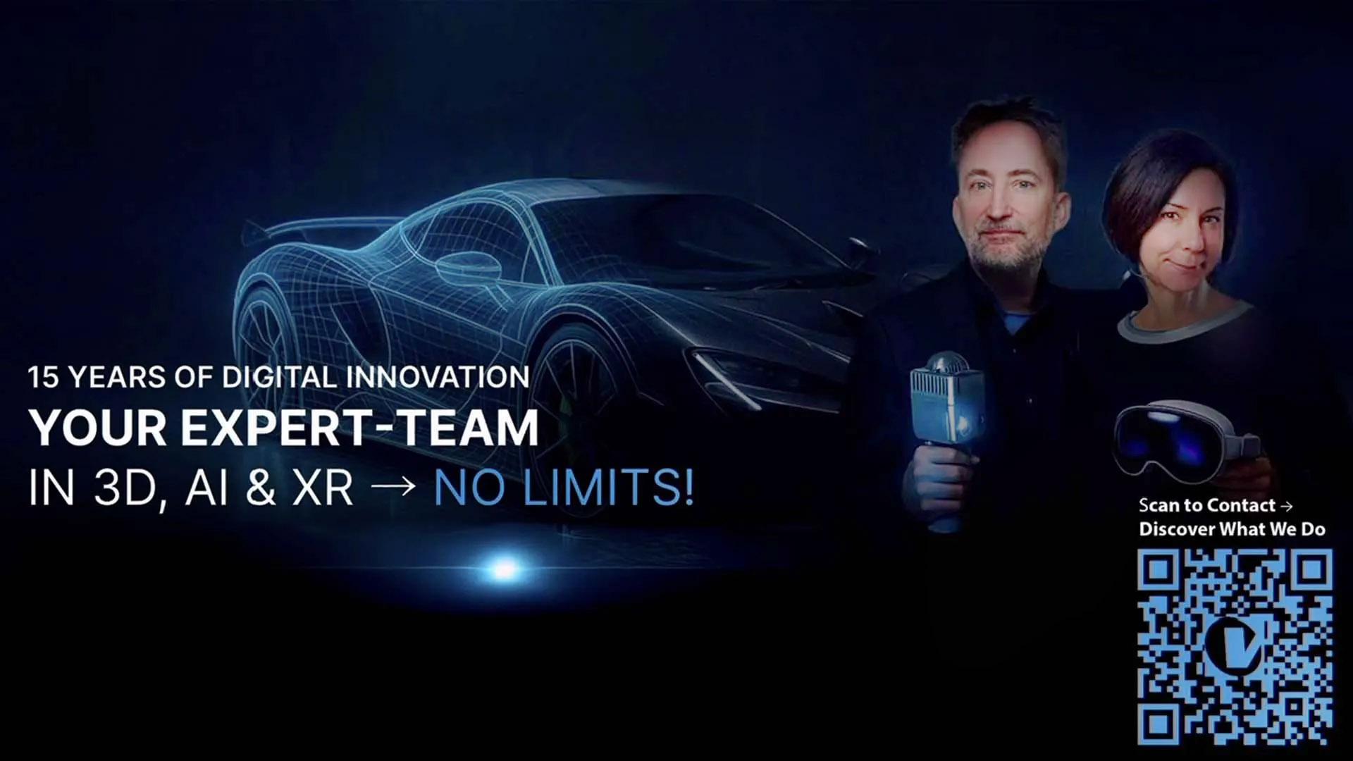
The VISORIC expert team: Ulrich Buckenlei and Nataliya Daniltseva in discussion about adaptive materials, AI driven vehicle concepts, and future mobility scenarios.
Source: VISORIC GmbH | Munich 2025
The scope of services deliberately goes beyond classic visualization. Visoric supports companies across the entire value chain of spatial 3D applications, from analyzing existing data structures to developing technical pipelines and enabling productive use within the organization.
- Strategic design of spatial 3D and mixed reality pipelines based on existing CAD data.
- Development of prototypes and proof of concepts for rapid validation of use cases.
- Creation of scalable software solutions for development, training, service, and marketing.
- Integration of real time 3D, mixed reality, and industrial AI into existing processes.
- Multi channel deployment of 3D assets across headsets, web, desktop, and mobile devices.
Whether the goal is one to one scale design reviews, immersive training scenarios, service oriented assistance systems, or high quality product communication, a stable technical and organizational foundation is essential. Visoric brings precisely this experience and supports companies in not only introducing spatial 3D technologies, but making them sustainably effective.
If you would like to explore how spatial 3D data, mixed reality, and intelligent 3D pipelines can be meaningfully applied in your organization, speak with the Visoric expert team. Together, solutions can be developed that are technically robust, economically sound, and scalable over the long term.
Contact Persons:
Ulrich Buckenlei (Creative Director)
Mobile: +49 152 53532871
Email: ulrich.buckenlei@visoric.com
Nataliya Daniltseva (Project Manager)
Mobile: +49 176 72805705
Email: nataliya.daniltseva@visoric.com
Address:
VISORIC GmbH
Bayerstraße 13
D-80335 Munich