

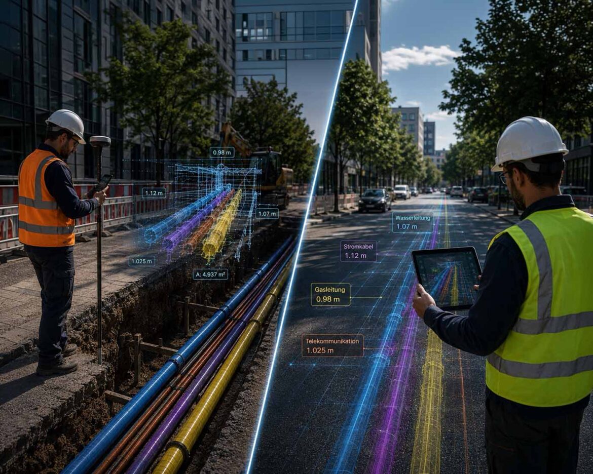
A technician surveys an open utility trench live, while his colleague already sees the same data as an augmented reality view on his tablet, water, power, gas, and telecommunications, located to the centimeter.
Visualization: Cyber-physical infrastructure capture in practice | Image: © Ulrich Buckenlei | XR Stager Online Magazine | VISORIC GmbH
Every year on August 11, the US-wide National 811 Day serves as a reminder to call the utility locating service before any digging project. The reason is soberingly concrete: in the service area of a single California energy provider alone, over 1,200 underground lines were damaged by digging in 2025, in more than half of those cases without anyone having contacted the locating service beforehand. Average repair costs run around $3,500 per incident, not to mention the safety risks involved.[1]
Swiss company Pix4D used this year’s 811 Day to show how to tackle exactly this problem at its root. With the app PIX4Dcatch, an ordinary smartphone, paired with an external RTK GNSS receiver, becomes a mobile surveying tool. As a technician simply walks alongside an open trench, a centimeter-accurate, georeferenced 3D model of the visible infrastructure emerges live, before the trench gets backfilled and everything visible disappears underground again.[2]
What stands out here as an impressive live demonstration is technically well explained and already independently verified by science. The combination of photogrammetry, LiDAR, and RTK positioning today reaches accuracy levels that were reserved exclusively for professional surveying equipment just a few years ago.
For spatial computing and digital twins, this is more than a clever tool for site managers. It shows exactly how reality capture, the digital recording of physical spaces, is moving out of specialized hardware and into an everyday part of industrial documentation.
- National 811 Day serves as an annual reminder to call the utility locating service before any digging project.
- Over 1,200 line damages at a single US utility in 2025 alone, average repair costs $3,500 per incident.
- PIX4Dcatch turns a smartphone with an external RTK receiver into a centimeter-accurate surveying tool.
- Capture happens live during normal walking, with no wait for a surveying crew.
- Reality capture is increasingly moving from specialized hardware into everyday, smartphone-based tools.
This article explains how smartphone-based RTK reality capture works technically, what independent research shows about its accuracy, where its limits lie, and why it’s becoming a core building block of modern digital twins for underground infrastructure.
From Paper Plan to Live Capture
Underground infrastructure, gas, water, power, and telecommunications lines, has for decades mostly been documented the way it looked at construction time: on paper plans, in incomplete archives, often without exact coordinates. The moment a trench gets backfilled, it’s not just the physical line that disappears from view, often the knowledge of exactly where it actually runs disappears too.
This gap between what was built and what’s documented is no fringe issue. According to the technical literature, it’s one of the central causes of damage during later construction work, because construction crews without reliable maps simply have no way of knowing what lies beneath the surface.[3] That’s exactly why the 811 campaign has existed in the US for years, carried by network operators and the Common Ground Alliance, with a simple message: call before every dig, so professionals can mark the location of existing lines.
The real problem, though, runs deeper. Even when marking happens correctly before a dig, what a construction crew could actually see during the open excavation often goes unused: the exact, three-dimensional position of the line, its depth, its path, its proximity to other utility lines. That exact window, open trench, clear line of sight, is the moment when underground infrastructure can be documented most precisely, and it’s exactly the moment that gets used the least systematically in practice.
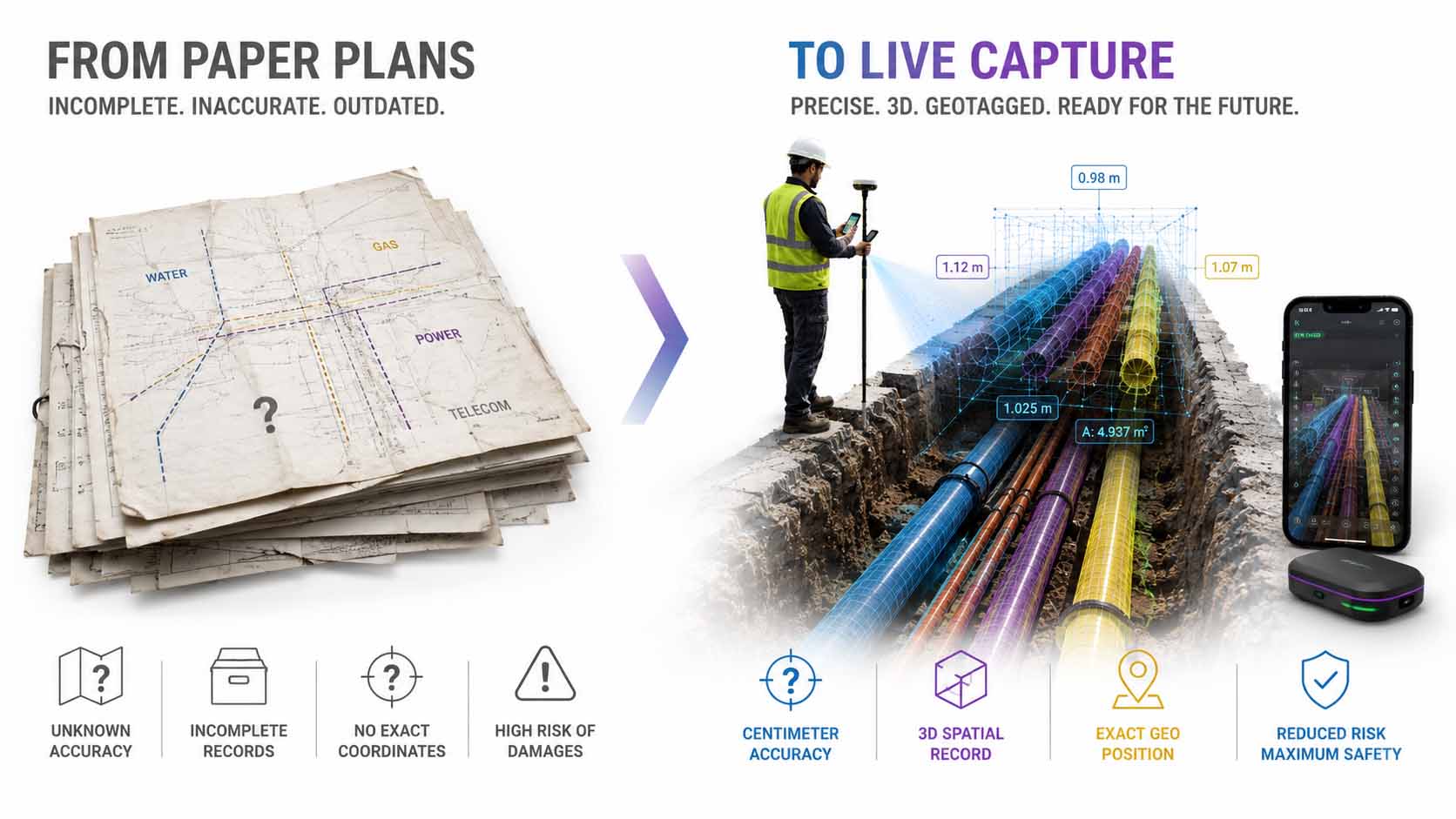
Underground infrastructure was documented for decades mostly on paper plans with no exact coordinates. The window of the open trench, where precise location capture would be possible, mostly went unused.
Infographic: From incomplete paper documentation to precise live capture during an open trench excavation | Graphic: © Ulrich Buckenlei | XR Stager Online Magazine | VISORIC GmbH
This shift, from an after-the-fact, often incomplete plan to capture at the moment of greatest visibility, fundamentally changes how reliable infrastructure data can become going forward. Instead of relying on assumptions and decades-old drawings, a dataset emerges that matches exactly what’s actually in the ground.
For field capture like this to be practical, it has to work fast, simply, and without specialized training, right within the normal workflow. How an ordinary smartphone technically meets that requirement is the subject of the next chapter.
- Underground infrastructure is traditionally documented on incomplete paper plans with no exact coordinates.
- Missing utility locate calls before digging are considered one of the main causes of infrastructure damage.
- The open-trench window offers the most precise documentation opportunity, yet is rarely used systematically.
- Precise live capture during excavation closes the gap between construction and documentation.
- Practical field capture has to work fast, simply, and without specialized training.
Why a Smartphone Suddenly Reaches Surveying Accuracy
That an ordinary smartphone can deliver centimeter-accurate 3D models sounds surprising at first. The technical foundation lies in a combination of three methods, each of which hits its own limits alone, but together achieve remarkably precise results.
The base is photogrammetry: from overlapping images of the same scene, taken from slightly different angles, a three-dimensional model gets calculated. High-precision reconstruction needs two things for that: optimal image overlap and precise tracking of camera movement. PIX4Dcatch automates this by detecting the user’s movement and automatically capturing images at optimal intervals, regardless of the person’s photographic skill.[4]
This gets complemented by the smartphone’s built-in LiDAR, which works reliably at short distances up to about five meters, but tends to produce blurrier, “thicker” point clouds than photogrammetry. Only the combination of both methods, photogrammetry as the foundation, LiDAR compensating for its weaknesses, delivers the necessary precision.[4] The decisive third building block comes from RTK positioning: an external GNSS receiver ties the capture to absolute, real-world coordinates and achieves centimeter-level accuracy, compared to the typical five-meter inaccuracy of ordinary smartphone GPS.[5]
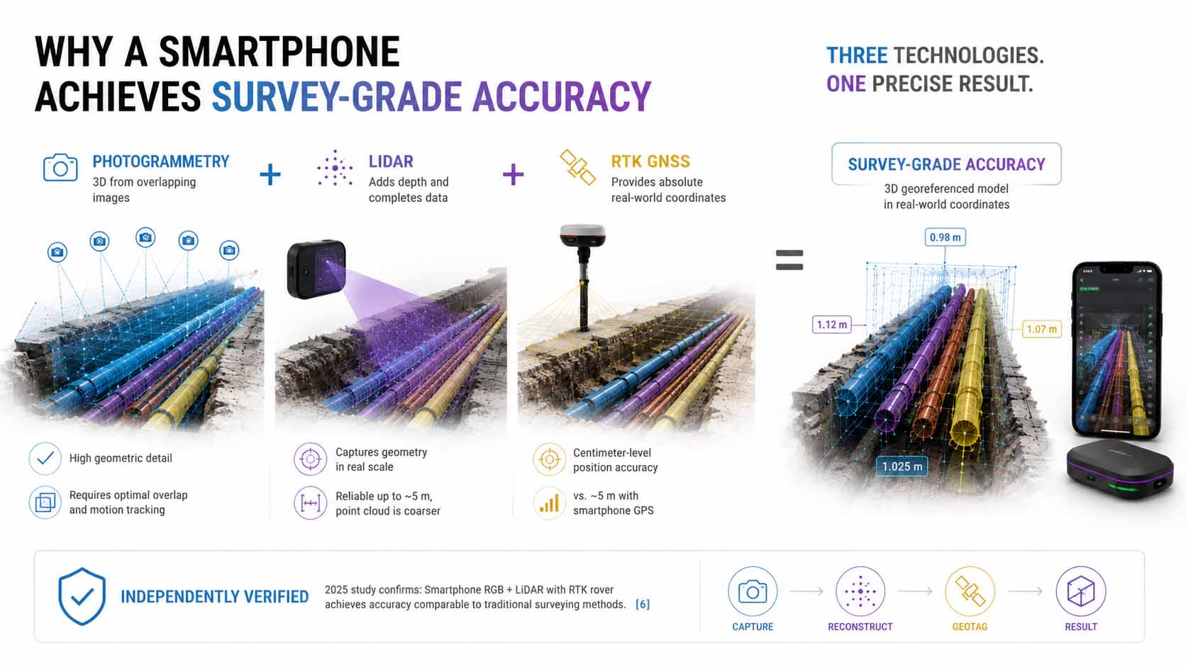
Only the interplay of photogrammetry, built-in LiDAR, and external RTK positioning delivers the accuracy needed for reliable infrastructure documentation. No single method alone is enough.
Infographic: Interplay of photogrammetry, LiDAR, and RTK-GNSS as the foundation of smartphone-based surveying accuracy | Graphic: © Ulrich Buckenlei | XR Stager Online Magazine | VISORIC GmbH
That this principle actually delivers on its promise is confirmed by independent scientific research. A study published in 2025 on the positioning accuracy of smartphone RGB and LiDAR sensors combined with an RTK rover found that the achieved accuracy is comparable to classic surveying methods in most cases studied, validated against a geodetic GNSS reference receiver.[6] For applications in construction, utilities, and infrastructure documentation, that’s a remarkable result, independently confirmed, not just claimed by the manufacturer.
This scientific confirmation matters, because it’s what separates a credible tool from an impressive but unreliable demo effect. Where this accuracy is actually reliably achieved, and where environmental conditions limit it, is covered in Chapter 4.
- Photogrammetry provides the geometric foundation but needs optimal image overlap and motion tracking.
- Built-in smartphone LiDAR complements photogrammetry but is limited to short distances.
- RTK-GNSS receivers deliver absolute coordinates at centimeter accuracy instead of the usual five-meter inaccuracy.
- Research confirms: the achieved accuracy is comparable to classic surveying methods in many cases.
- Only the interplay of all three methods delivers the precision needed for infrastructure documentation.
Digital Twins Preserve What Physically Disappears
A single precise 3D model of an open trench is valuable. Its real potential, though, only unfolds once it becomes part of a larger, lasting digital twin that stays usable far beyond the moment of capture.
Current research on digital twins of underground utility tunnels shows how Building Information Modeling and Geographic Information Systems, BIM and GIS for short, can be combined to turn individual captures into a continuous, spatially anchored model. Multimodal image sensors, including LiDAR, help automatically break down the structure of underground facilities into points, lines, and surfaces, and preserve them as a reusable digital model.[7]
Another line of research goes a step further: a recently presented framework integrates BIM, GIS, and augmented reality specifically for visualizing and managing multiple underground utility lines at once, with a significantly higher level of detail than earlier approaches. While older studies often represented lines only roughly and approximately, this approach enables realistic 3D visualization with complete geometric, non-geometric, and geospatial information directly within the real environment.[8]
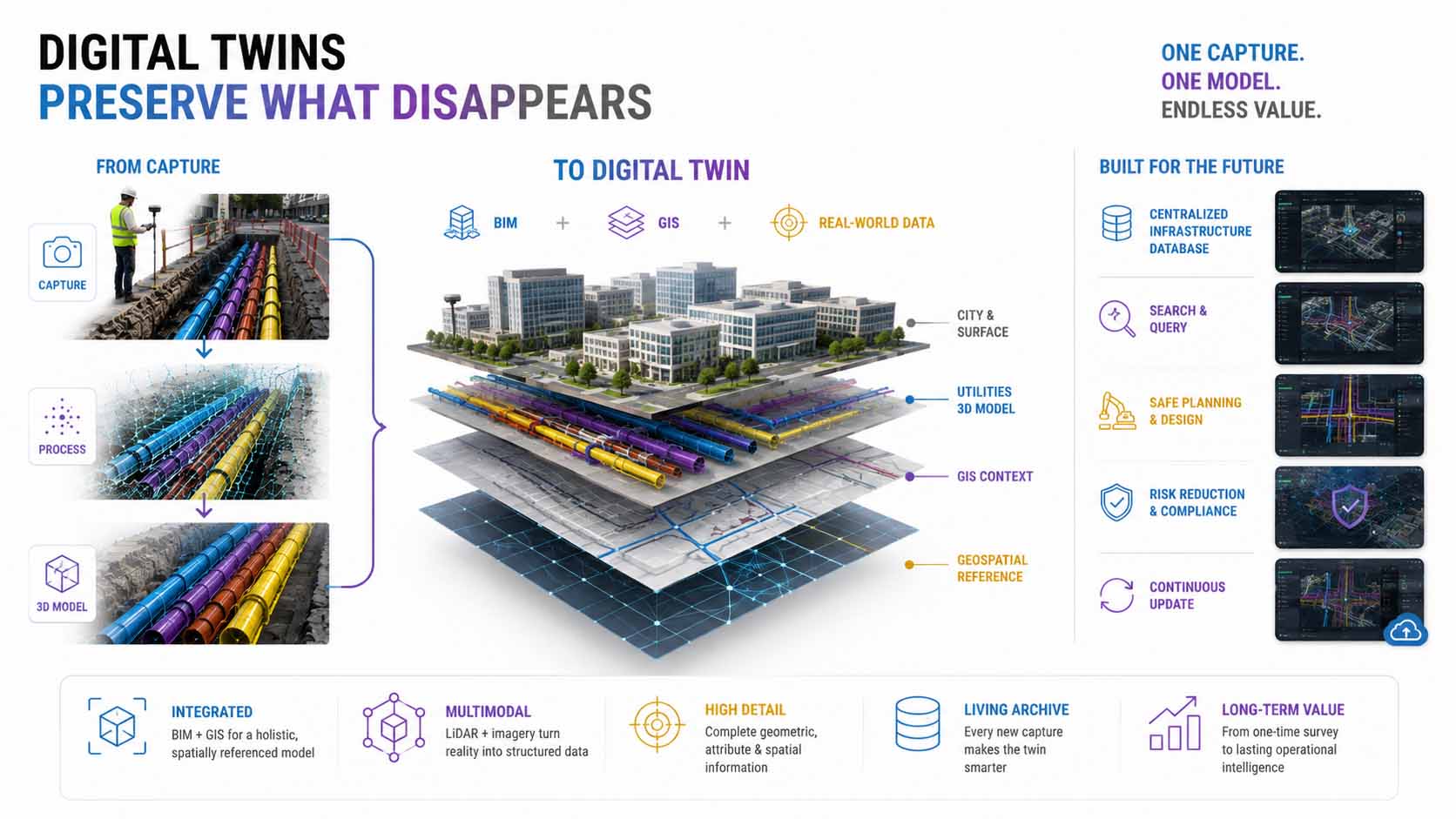
Digital twins combine BIM, GIS, and precise capture data into a lasting, reusable model of underground infrastructure, usable well beyond the individual capture moment.
Infographic: BIM-GIS integration as the foundation of lasting digital twins for underground utility infrastructure | Graphic: © Ulrich Buckenlei | XR Stager Online Magazine | VISORIC GmbH
For operators of complex utility networks, this means a fundamental shift. Instead of isolated, one-off surveying projects, a continuously growing, searchable archive emerges, becoming more complete with every new capture. A digital twin thereby stops being a one-time snapshot and becomes a living, continuously updating representation of the actual infrastructure.
For a model like this to stay reliable years down the line, it has to remain clear what it actually shows, and what it doesn’t. That exact distinction is the subject of the next chapter.
- Digital twins combine BIM and GIS into a continuous, spatially anchored infrastructure model.
- Multimodal sensors automatically break down underground structures into reusable digital building blocks.
- Newer frameworks integrate multiple utility lines simultaneously with a high level of geometric detail.
- Individual surveying projects turn into a continuously growing, searchable infrastructure archive.
- A digital twin thereby becomes a continuously updating representation instead of a one-time snapshot.
Why the Capture Shows What Was, Not What Is Now
As convincing as precise 3D capture looks, it has an important, often overlooked limitation: it documents exactly the state at the time of capture, not necessarily the current state years later. A line that has since corroded, shifted, or been damaged still appears in a stored AR model exactly as it looked at capture time.
Current research names this limitation openly too. A comprehensive review of AR visualization methods for underground utility lines finds that existing AR applications rely predominantly on static data, while dynamic, changing information is rarely captured systematically, a clearly identified research gap for the years ahead.[9] A stored 3D model reliably shows where a line is located, not necessarily what condition it’s currently in.
Raw capture accuracy itself isn’t a fixed quantity either, it depends heavily on environmental conditions. A study on the accuracy of smartphone LiDAR in forested terrain shows that precision noticeably degrades under dense canopy cover or on steep slopes, with horizontal errors exceeding one meter, making mobile LiDAR unsuitable as a standalone solution for precise surveying under such conditions.[10] For open construction sites with a clear view of the sky, as is the case at most utility trenches, these limitations are far less relevant, though they don’t disappear entirely.
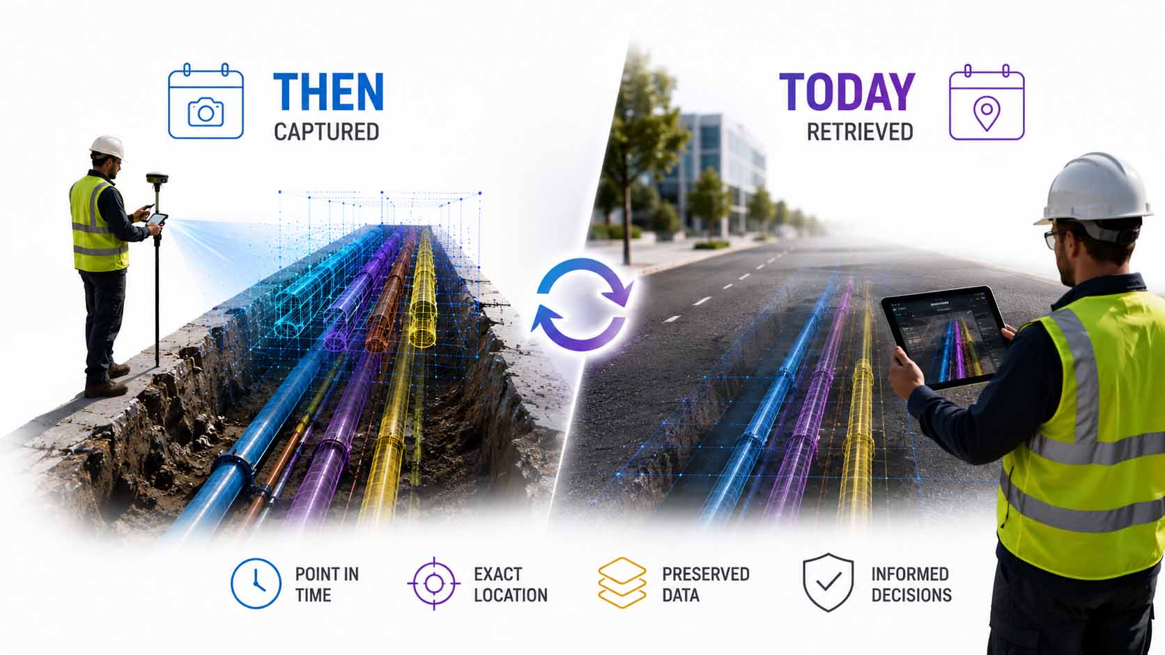
A stored 3D model reliably shows where a line was located at capture time, not necessarily its current physical condition. Capture accuracy itself also depends heavily on environmental conditions.
Infographic: Limits of smartphone-based reality capture, a static snapshot instead of real-time condition, and environmental effects on capture accuracy | Graphic: © Ulrich Buckenlei | XR Stager Online Magazine | VISORIC GmbH
These limitations aren’t a reason to question the technology, they’re a reason to put it in the right context. A precise, georeferenced 3D model doesn’t replace a physical condition inspection of a line, but it reliably replaces the previous alternative: having no reliable documentation of the original location at all.
Knowing where that line sits allows for a realistic assessment of the technology and its targeted use exactly where it makes the biggest difference. Which industries are already doing that today is the subject of the next chapter.
- A stored 3D model shows the state at capture time, not necessarily the current state.
- Current research names missing dynamic data integration as an open point for AR infrastructure visualization.
- Capture accuracy noticeably degrades under dense canopy cover or on steep slopes.
- Open construction sites with a clear view of the sky are far less affected by these limitations.
- The technology doesn’t replace condition inspection, but reliably replaces missing location documentation.
A Technology for Utilities, Construction, and Insurance
Once it’s clear what smartphone-based reality capture can deliver and where its limits lie, its practical value becomes easy to place: anywhere infrastructure needs documenting before it becomes physically inaccessible.
For utility companies and municipalities, the benefit is immediately tangible. One user’s account puts it plainly: a lot of information still exists only on paper and is poorly documented, a surveying tool that can be used directly at the open trench lets crews scan it and close it back up without waiting for a separate surveying team. That speeds up work on site while giving the office full clarity on what actually happened in the field.[11]
In construction and utilities, users also report a concrete economic effect: by forgoing expensive specialized surveying equipment and specialized personnel, overall project costs drop noticeably, while documentation quality rises at the same time.[2] For insurers, meanwhile, another application field opens up: a reliable, time-stamped 3D record of a line’s original condition can be decisive in resolving liability questions in the event of a claim.
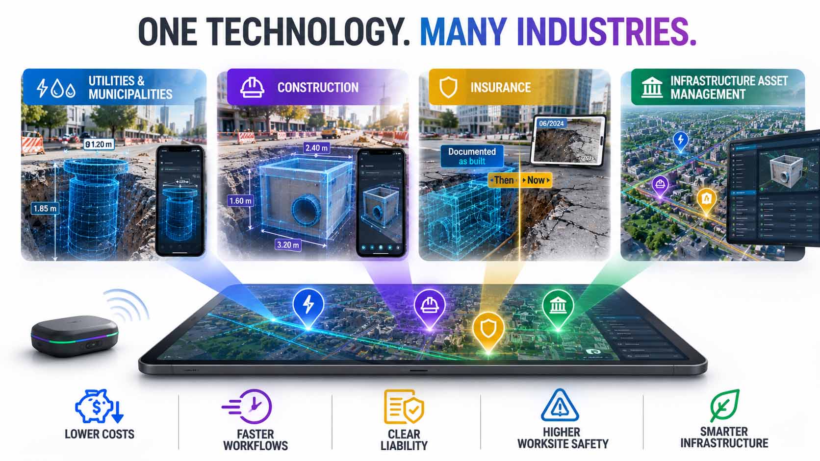
Smartphone-based reality capture is already in use across industries: from utility companies through construction to insurance and municipal infrastructure management.
Infographic: Application fields for smartphone-based reality capture in utilities, construction, and insurance | Graphic: © Ulrich Buckenlei | XR Stager Online Magazine | VISORIC GmbH
What all these applications share is a central economic advantage: the average repair cost of about $3,500 per line damage can be significantly reduced through precise upfront documentation, while site safety improves at the same time.[1] For operators with extensive utility networks, that’s a double win, fewer damages alongside lower surveying effort.
This range of applications raises an obvious question: how can this static but precise model be tied even more closely to the actual, changing condition of a facility going forward? That’s exactly the subject of the next chapter.
- Utility companies use the technology to replace paper documentation with precise live capture.
- Construction companies save on costs for specialized equipment and specialized surveying personnel.
- Insurers can use documented original conditions to help resolve liability questions.
- Municipalities build searchable, permanently usable digital utility archives.
- Precise upfront documentation reduces repair costs while increasing job-site safety.
When Sensor Data Ushers In the Next Step
A precise, georeferenced 3D model is an excellent foundation, but as shown in Chapter 4, it remains a snapshot. The next logical development step lies in connecting this spatial foundation with continuously updated sensor data, instead of leaving it as a one-time capture.
That exact direction is already taking shape in current research. The digital-twin framework for underground utility tunnels described in Chapter 3 is explicitly designed so that multimodal sensor data can be fed continuously into the spatial model, turning a static structure into a continuously updating representation.[7] A recent study on mobile AR visualization for the full lifecycle of urban pipe networks also explicitly identifies the integration of dynamic, multi-source data as one of the most important future research priorities, alongside predictive maintenance and automated inspection systems.[12]
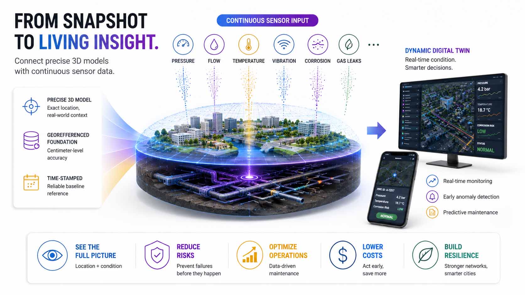
The next development step connects the precise spatial model with continuously updated sensor data, turning a one-time capture into a continuously updating representation of the actual condition.
Infographic: Connecting precise spatial capture with continuous sensor data integration as the next development step | Graphic: © Ulrich Buckenlei | XR Stager Online Magazine | VISORIC GmbH
For operators of critical infrastructure, the effect would be substantial. Instead of a model that merely shows where a line runs, a model would emerge that also shows what condition it’s currently in, supplemented by readings on pressure, corrosion, or temperature, located directly at the exact, previously captured position.
This step, from pure spatial documentation to continuously updated condition monitoring, is technically demanding but by no means science fiction. It builds directly on already-established capture technology and shows where the entire reality-capture industry is currently heading. Just how open and dynamic this field really is becomes clear in the next chapter.
- A precise 3D model starts out as a static snapshot of the capture moment.
- Digital-twin frameworks are increasingly designed to allow continuous sensor data feeds.
- Current research names dynamic data integration explicitly as a key future research priority.
- Combined with sensor data, location documentation would become continuous condition monitoring.
- This step builds directly on already-established capture technology instead of replacing it.
From Specialized Device to Everyday Tool
Just a few years ago, precise 3D capture was reserved almost exclusively for specialists with correspondingly expensive equipment, terrestrial laser scanners, professional surveying drones, trained personnel. Current industry analyses show that this picture has fundamentally changed by 2026.
The industry hasn’t settled on a single tool, but on hybrid workflows that deliberately combine different capture technologies. Terrestrial laser scanners and mobile SLAM scanning are now considered the industry standard, achieving three to five millimeters of accuracy while being ten to fifteen times faster than traditional methods, while mobile scanning cuts field costs by 50 to 70 percent.[13] An by-now established pattern combines drone photogrammetry for exterior capture with smartphone LiDAR for interiors and hard-to-reach details, a hybrid workflow that has become common enough to be considered standard practice.[14]
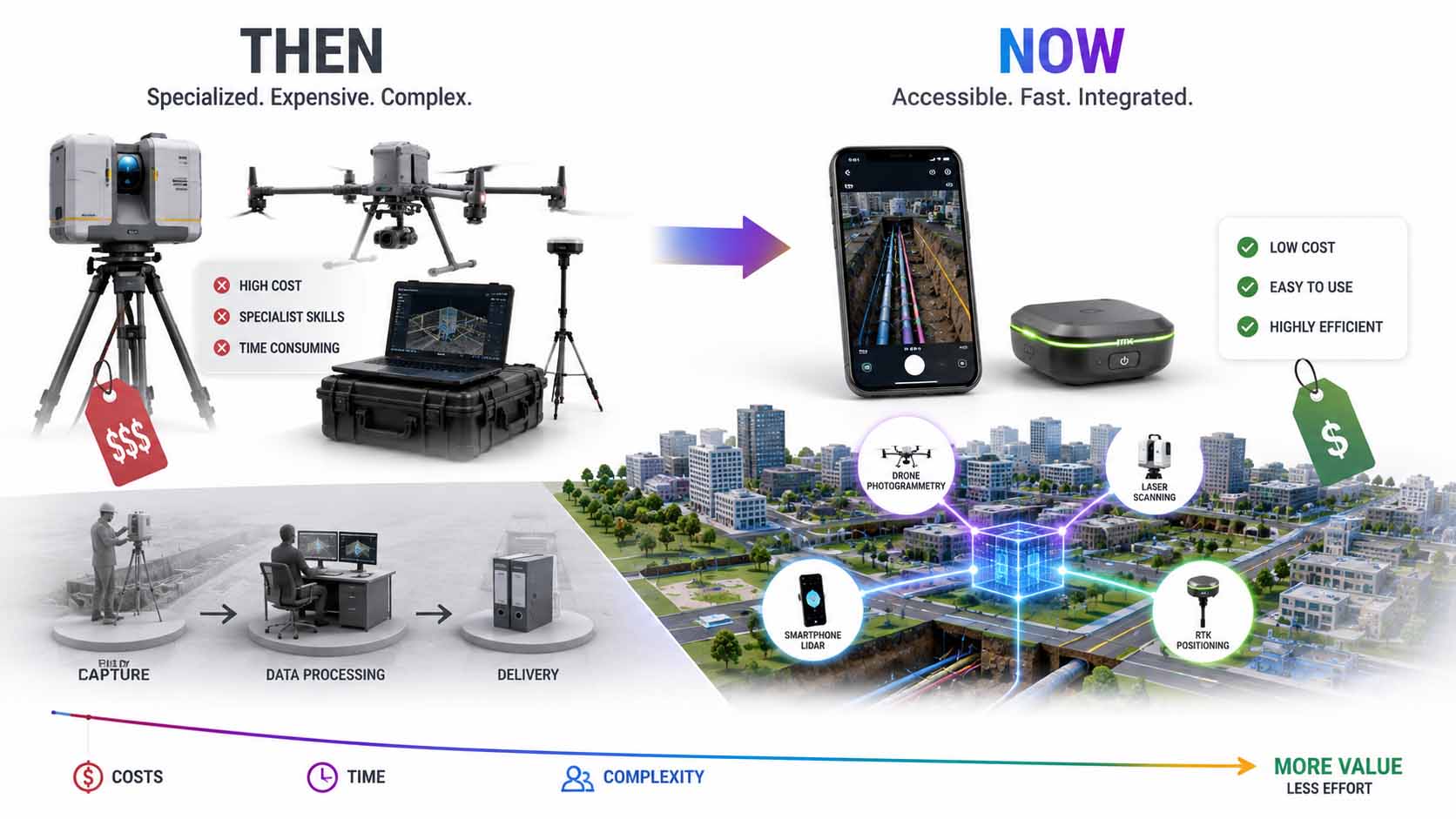
Precise 3D capture, once reserved exclusively for expensive specialized equipment, is now part of hybrid workflows that deliberately combine drones, laser scanners, and smartphones, significantly cutting field costs.
Infographic: Evolution from specialized hardware to hybrid, everyday-usable reality-capture workflows | Graphic: © Ulrich Buckenlei | XR Stager Online Magazine | VISORIC GmbH
For companies, this development means a noticeably lower barrier into a demanding technology. Instead of having to invest in expensive specialized equipment, a large share of infrastructure documentation can already be done today with devices many teams already own, supplemented by relatively inexpensive RTK add-on hardware.
At the same time, this development shows how progress in the reality-capture industry as a whole tends to happen: not through a single technological breakthrough, but through the growing availability and combinability of already-existing methods. How this development fits into the bigger picture of the digital-twin ecosystem is the subject of the final chapter.
- Precise 3D capture was long reserved exclusively for specialists with expensive equipment.
- Hybrid workflows now deliberately combine laser scanners, drones, and smartphones.
- Mobile scanning cuts field costs industry-wide by 50 to 70 percent.
- Drone photogrammetry for exteriors and smartphone LiDAR for interiors are considered established standard practice.
- Progress comes from combining existing methods, not from a single technological leap.
Reality Capture as the Next Stage of the Digital Twin Ecosystem
The previous chapters have shown how smartphone-based reality capture works technically, what accuracy it achieves under independent scrutiny, where its limits lie, and which industries are already using it today. Together, these building blocks form a principle that reaches far beyond individual surveying projects.
Current industry observations confirm what’s already emerging in this article: the workflow of drone photogrammetry for exteriors combined with smartphone LiDAR for interior and close-range areas is now common enough to have become a fixed pattern across the entire industry.[14] That makes clear: what starts with a single utility trench fits into a much larger development trajectory, one that ultimately touches all the previously invisible or poorly documented parts of our built environment.
For digital twins as a whole, this means an important expansion. Until now, many digital-twin projects focused on what’s already visible and easily accessible, buildings, facilities, production lines. Precise, everyday-usable reality capture now systematically opens up what normally stays invisible too: underground lines, temporary construction states, hard-to-reach details. Digital twins thereby become not just more precise, but more complete.
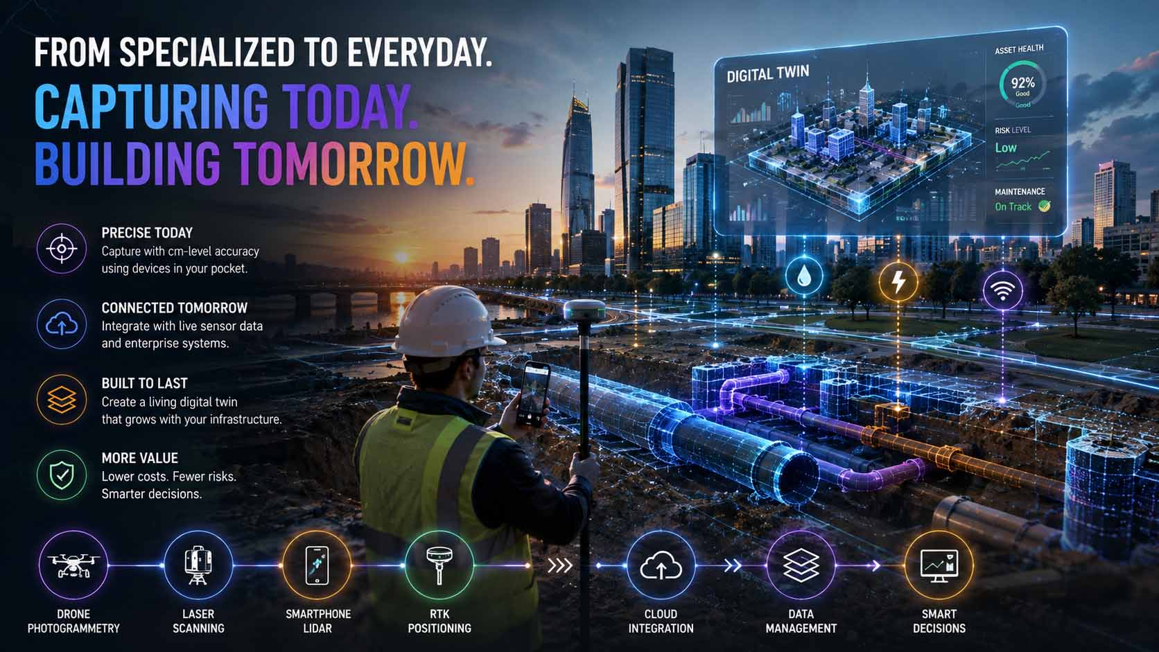
Smartphone-based reality capture systematically opens up what normally stays invisible for digital twins, underground infrastructure and temporary construction states, making digital twins more complete as a result.
Infographic: Smartphone-based reality capture as an extension of the digital twin ecosystem into previously invisible infrastructure layers | Graphic: © Ulrich Buckenlei | XR Stager Online Magazine | VISORIC GmbH
For companies investing in digital twins and spatial computing, this leads to a clear strategic conclusion. Infrastructure data that can be captured precisely today with comparatively little effort can no longer be reconstructed after the fact tomorrow, once a trench is backfilled or a temporary state has vanished. Whoever uses these capture windows systematically builds an infrastructure archive that gains value over decades.
Research and early broad industrial adoption show that this capability is already technically mature, scientifically vetted, and economically viable today. The path from an impressive live demonstration to everyday, company-wide practice is, for companies that act now, considerably shorter than it might first appear.
- Hybrid capture workflows combining drones and smartphones are now established industry practice.
- Reality capture extends digital twins with previously invisible infrastructure layers.
- Underground lines and temporary construction states become systematically documentable for the first time.
- Unused capture windows can no longer be reconstructed after the fact.
- The path from demonstration to company-wide practice is considerably shorter today than before.
This brings the article full circle. What starts with a smartphone at a single utility trench is turning into a foundational principle for the next generation of digital twins. Just how convincing this principle already is in practice is shown in the following video.
When a Trench Becomes Visible Again, Long After It’s Closed
The previous chapters have shown how smartphone-based reality capture works technically, what accuracy it achieves, and where its limits lie. How convincing this principle already is in practice becomes most obvious in a direct look at a real-world capture.
The following video shows a live capture by Pix4D for National 811 Day: an iPhone, paired with an RTK receiver, captures an open utility trench on a residential street. Live measurements, area values, and RTK fix status are visible directly in the camera feed, while a precise, color-segmented 3D mesh of the line takes shape.[2] Particularly telling is that the same stored model can later be overlaid again via augmented reality onto the already-backfilled trench, at exactly the same, RTK-referenced position.
This moment, making a line that’s long since underground visible again, makes immediately clear what the previous chapters explained technically: physical reality disappears, the precisely captured digital information remains.
Video: Smartphone RTK reality capture of an open utility trench for National 811 Day | Visuals by original creators Pix4D (@pix4d_official) | Analysis, script, editing, and video production: © Ulrich Buckenlei | XR Stager Online Magazine | VISORIC GmbH
The video makes clear that precise infrastructure capture isn’t some distant future concept, it already works today with off-the-shelf hardware, right on site, with no surveying crew and no waiting. For companies thinking about digitizing their own infrastructure documentation, this example shows just how close a practical rollout already is.
At the same time, the video reveals the key conceptual difference: it’s not the individual 3D capture that stands out, it’s the fact that the same information can be retrieved years later at exactly the same real-world position. That’s exactly what turns a technical demonstration into a reliable infrastructure archive.
- The video shows a real live capture by Pix4D for National 811 Day.
- Live measurements, area values, and RTK fix status are visible directly in the camera feed.
- The stored 3D model can later be overlaid again onto the already-backfilled trench.
- The technology already works today with off-the-shelf hardware right on site.
- What matters is the lasting retrievability of the same precise position over the years.
This example makes tangible where reality capture is heading: from an impressive live demonstration to a reliable, lasting archive of everything that actually lies beneath our streets.
From Idea to Precise Infrastructure Archive
Precise reality capture doesn’t come from a single device or a single app, it comes from the thoughtful interplay of suitable hardware, the right capture strategy, and integration into a permanently usable digital-twin system. That exact combination sits at the core of what VISORIC builds for its clients.
The expert team at VISORIC GmbH in Munich combines over 15 years of experience in 3D, AI, and XR with hands-on expertise in reality capture, digital twins, and real-time 3D, exactly the building blocks a reliable infrastructure archive needs. Whether it’s underground lines, construction progress, or hard-to-reach facility areas, VISORIC builds the technical bridge from precise field capture to a permanently usable digital twin, tailored to a company’s actual requirements.

15 years of experience in 3D, AI, and XR: the VISORIC expert team from Munich.
Image: © Ulrich Buckenlei | XR Stager Online Magazine | VISORIC GmbH
A well-thought-out pilot project, a single construction section, a single utility network, can often be realized considerably faster and more cost-effectively than many companies expect. VISORIC guides that journey from the first concept idea, through the technical capture strategy, to a deployment-ready, permanently usable digital twin.
- Concept development and implementation of smartphone-based reality capture for utilities, construction, and facility management.
- Integration of precise capture data into existing digital twins and GIS systems.
- From the first pilot application to a company-wide, permanently usable infrastructure archive.
Want to precisely document underground lines, temporary construction states, or hard-to-reach facility areas and preserve them permanently in a digital twin?
Talk to the VISORIC expert team from Munich about reality capture, digital twins, and modern spatial computing platforms. Together, we’ll turn your requirements into a precise, permanently usable infrastructure archive, with a noticeable edge in cost, safety, and traceability.
Contact:
Email: info@visoric.com
Phone: +49 89 21552678
Sources and References
- National 811 Day. Damaging Underground Utility Lines During Digging Can Be a Serious Public Safety Issue. PR Newswire, August 2026.
- Pix4D (@pix4d_official). National 811 Day live demonstration of PIX4Dcatch with RTK positioning. Instagram, August 2026.
- Augmented Reality Geovisualisation for Underground Utilities. PFG – Journal of Photogrammetry, Remote Sensing and Geoinformation Science, Springer Nature.
- How Does PIX4Dcatch Achieve Professional Accuracy? Pix4D Blog.
- PIX4Dcatch FAQ, RTK Pricing Page. Pix4D, positioning accuracy figures with and without an RTK receiver.
- Evaluation of Positioning Accuracy Using Smartphone RGB and LiDAR Sensors with the viDoc RTK Rover. MDPI Sensors, June 2025.
- Implementing a Digital Twin of an Underground Utility Tunnel for Geospatial Feature Extraction Using a Multimodal Image Sensor. MDPI Applied Sciences, 2023.
- Integration of Building Information Modeling, Geographic Information System, and Augmented Reality for Visualization and Management of Multiple Underground Utilities. Journal of Pipeline Systems Engineering and Practice, ASCE.
- A Review of Augmented Reality Visualization Methods for Subsurface Utilities. ScienceDirect, Tunnelling and Underground Space Technology.
- Accuracy Assessment of iPhone LiDAR for Mapping Streambeds and Small Water Structures in Forested Terrain. MDPI Sensors, October 2025.
- Unlock the Full Potential of Your PIX4Dcatch Projects with RTK. Pix4D, user interview on municipal and government use cases.
- Mobile Augmented Reality-Based Visualization Framework for Lifecycle O&M Support of Urban Underground Pipe Networks. ScienceDirect, Tunnelling and Underground Space Technology, 2023.
- Reality Capture for Surveyors: 3D Scanning Guide 2026. Kingston Surveyors.
- Photogrammetry News: Industry Trends & Technology in 2026. Skyebrowse.
- Pix4D (@pix4d_official). Live video of PIX4Dcatch RTK capture of a utility trench, published for National 811 Day, August 2026.
- VISORIC practice projects in reality capture, digital twins, real-time 3D, and spatial computing.
- XR Stager platform for real-time 3D, digital twins, knowledge AI, and industrial spatial computing applications.
Contact Persons:
Ulrich Buckenlei (Creative Director)
Mobile: +49 152 53532871
Email: ulrich.buckenlei@visoric.com
Nataliya Daniltseva (Project Manager)
Mobile: +49 176 72805705
Email: nataliya.daniltseva@visoric.com
Address:
VISORIC GmbH
Bayerstraße 13
D-80335 Munich